IMAGES TAKEN NEAR TO
The Straight Mile, OXFORD, OX33 1AD
Introduction
This page details the photographs taken nearby to The Straight Mile, OX33 1AD by members of the Geograph project.
The Geograph project started in 2005 with the aim of publishing, organising and preserving representative images for every square kilometre of Great Britain, Ireland and the Isle of Man.

There are currently over 7.5m images from over14,400 individuals and you can help contribute to the project by visiting https://www.geograph.org.uk
Image Map
Images are licensed for reuse under creativecommons.org/licenses/by-sa/2.0
Notes
- Clicking on the map will re-center to the selected point.
- The higher the marker number, the further away the image location is from the centre of the postcode.
Image Listing (7 Images Found)
Images are licensed for reuse under creativecommons.org/licenses/by-sa/2.0
Image
Details
Distance
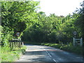
1
Straight Mile Road to Horton cum Studley
Image: © Steve Daniels
Taken: 20 Mar 2014
0.07 miles
2
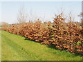
Beech hedge, Horton cum Studley
The hedge is alongside the road outside the entrance to Studley Wood Golf Club. Beech hedges often keep their leaves through the winter, until they are replaced by new ones in the spring.
Image: © David Hawgood
Taken: 1 Apr 2007
0.08 miles
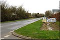
3
Studley Wood Golf Club entrance
The area between this road entrance and the golf course has been landscaped with new trees.
Image: © David Hawgood
Taken: 1 Apr 2007
0.10 miles
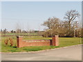
4
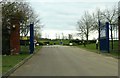
The entrance to Studley Wood Golf Club
Image: © Steve Daniels
Taken: 20 Mar 2014
0.10 miles
5
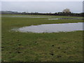
Oxfordshire Way
A watery Oxfordshire Way by Haynes Farm heading to Beckley
Image: © Shaun Ferguson
Taken: 25 Feb 2009
0.22 miles
6
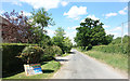
Church Lane, Horton-cum-Studley
Church Lane is a no through road heading west out of the village towards various tracks and bridleways. The sign on the verge is showing support for the National Health Service and other key workers during the coronavirus epidemic of 2020.
Image: © Des Blenkinsopp
Taken: 1 Jun 2020
0.23 miles