IMAGES TAKEN NEAR TO
Marston Road, OXFORD, OX3 0EG
Introduction
This page details the photographs taken nearby to Marston Road, OX3 0EG by members of the Geograph project.
The Geograph project started in 2005 with the aim of publishing, organising and preserving representative images for every square kilometre of Great Britain, Ireland and the Isle of Man.

There are currently over 7.5m images from over14,400 individuals and you can help contribute to the project by visiting https://www.geograph.org.uk
Image Map
Images are licensed for reuse under creativecommons.org/licenses/by-sa/2.0
Notes
- Clicking on the map will re-center to the selected point.
- The higher the marker number, the further away the image location is from the centre of the postcode.
Image Listing (114 Images Found)
Images are licensed for reuse under creativecommons.org/licenses/by-sa/2.0
Image
Details
Distance
1
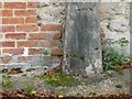
Old Boundary Marker at King's Mill House, Oxford parish
Parish Boundary Marker by River Cherwell mill leat, in parish of Oxford (Oxford District), against the West wall of King's Mill House, visible from a public footpath from Marston Road that leads to Mesopotamia Walk.
Inscription reads:-
J. WYATT
MAYOR
WARBURTON
SHERIFF
(James Wyatt was Mayor of Oxford in 1842/3.)
Surveyed
Milestone Society National ID: OX_OX08pb
Image: © Milestone Society
Taken: Unknown
0.00 miles
2
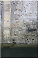
Benchmark on west face of Kings Mill House
Ordnance Survey cut mark benchmark described on the Bench Mark Database at http://www.bench-marks.org.uk/bm56001
Image: © Roger Templeman
Taken: 24 Mar 2014
0.01 miles
3
Kings Mill house
There is an OS benchmark Image above the stream to the right of the vertical line of stones in the stone face of the house. The boundary stone against the wall of the house marks the Ward and Union boundary and probably dates from 1842. Its legend reads: ‘J. W Y A T T/ M A Y O R/W A R B U R T O N
/S H E R I F F’. James Wyatt was Mayor of Oxford in 1842/3.
Image: © Roger Templeman
Taken: 24 Mar 2014
0.01 miles
4
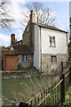
King's Mill Lane Area, Oxford
King's Mill on the eastern bank of the River Cherwell, with the mill race sluice and a footpath - just visible - that links Mesopotamia Walk and Linacre College in St Cross Road (behind the photographer) with King's Mill Lane (behind the mill). A mill was recorded at this site in the Domesday Book, and milling did not cease here until as late as 1825. The stone tablet (boundary marker?) beneath the window in the single-storey part of the property reads: "J.Wyatt, Mayor + Warburton, Sheriff + 1843". James Wyatt (1774–1853) was a wood carver and gilder specialising in making and selling ornate picture frames. He was the Mayor of Oxford for the 1842/3 period. George H. Warburton (1795–1861) was a successful grocer and was elected Sheriff of Oxford for 1843/4. He was also made an Alderman on 9 November 1850, the same day that he was elected Mayor of Oxford for 1850/1. The mill appears to be a private residence at present.
Image: © David Hallam-Jones
Taken: 1 Aug 2013
0.01 miles
5
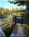
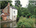
The Mill Race, Kings Mill
There was a mill recorded here in the Domesday Book, and milling continued until 1825.
Image: © Des Blenkinsopp
Taken: 7 Nov 2012
0.02 miles
6
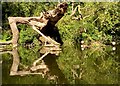
Timber sculpture
A fallen tree, reflected in the river, resembles a wild animal sculpture.
Image: © Alan Hughes
Taken: 15 Sep 2019
0.02 miles
7
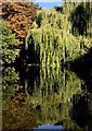
Tree tranquillity
Trees reflected in calm waters.
Image: © Alan Hughes
Taken: 15 Sep 2019
0.03 miles
8
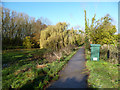
Mesopotamia Walk
I don't know if this name is still in use for this piece of land, but here is what Wikipedia says about it:
"Mesopotamia is a narrow island (about 800 yards long by 30 yards wide) that forms part of the University Parks. It lies between the upper and lower levels of the River Cherwell. The name Mesopotamia in Greek means 'between the rivers' and originally referred to the area between the Tigris and Euphrates rivers in present-day Iraq. The land was purchased by the University of Oxford during the expansion of the Oxford University Parks between 1860 and 1865. A footpath, Mesopotamia Walk, laid out in 1865 runs along the centre of the spur to Kings Mill.
"The Domesday Book records a watermill on this site and milling continued until 1825; one level of the river was once the mill stream. From 1914, attempts were made to introduce wild ducks and geese to the area, but these proved fruitless because of the predatory local otter population. Until 1926, a ferry operated from a point halfway along the Walk, when it was replaced by a footbridge."
The green kiosk is an Environment Agency flood warning station which monitors river levels.
Image: © Des Blenkinsopp
Taken: 7 Nov 2012
0.04 miles
9
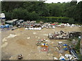
Oxford Centre for Islamic Studies, site for garden
This area currently in use as a construction yard will become a garden. View from 3rd floor roof above dining hall, during Oxford Open Doors.
Image: © David Hawgood
Taken: 14 Sep 2013
0.06 miles
10
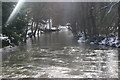
River Cherwell.
Looking downstream from the end of Kings Mill Lane
Image: © Chris Denny
Taken: 7 Feb 2009
0.07 miles