IMAGES TAKEN NEAR TO
Faringdon Road, OXFORD, OX2 9QY
Introduction
This page details the photographs taken nearby to Faringdon Road, OX2 9QY by members of the Geograph project.
The Geograph project started in 2005 with the aim of publishing, organising and preserving representative images for every square kilometre of Great Britain, Ireland and the Isle of Man.

There are currently over 7.5m images from over14,400 individuals and you can help contribute to the project by visiting https://www.geograph.org.uk
Image Map
Images are licensed for reuse under creativecommons.org/licenses/by-sa/2.0
Notes
- Clicking on the map will re-center to the selected point.
- The higher the marker number, the further away the image location is from the centre of the postcode.
Image Listing (16 Images Found)
Images are licensed for reuse under creativecommons.org/licenses/by-sa/2.0
Image
Details
Distance
1
Benchmark on Ridgeway car sales
Ordnance Survey flush bracket (serial number 10708) benchmark described on the Bench Mark Database at http://www.bench-marks.org.uk/bm21990
Image: © Roger Templeman
Taken: 19 Oct 2015
0.03 miles
3
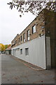
Ridgeway Rover dealership
There is an OS benchmark Image on the near corner of the building fixed in the grey-painted bricks below the white ones.
Image: © Roger Templeman
Taken: 19 Oct 2015
0.04 miles
4
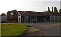
Former car showrooms, A420 near Henwood
"We have moved" in the window, but no explanation of who "we" might be except the website
Image: © David Smith
Taken: 24 Aug 2017
0.05 miles
5
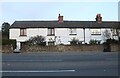
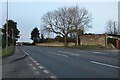
Rockley Cottages on Faringdon Road, Bessels Leigh
Image: © David Howard
Taken: 5 Feb 2023
0.08 miles
6
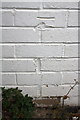
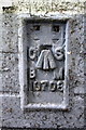
Benchmark on #7 Rockley Cottages
Ordnance Survey cut mark benchmark described on the Bench Mark Database at http://www.bench-marks.org.uk/bm71293
Image: © Roger Templeman
Taken: 19 Oct 2015
0.09 miles
7
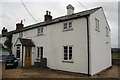
#7 Rockley Cottages, Faringdon Road
There is an OS benchmark Image on the front of the house at the junction of the original house and its right hand extension
Image: © Roger Templeman
Taken: 19 Oct 2015
0.09 miles
8
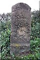
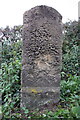
Old Milestone by the A420, south of Cumnor
Carved stone post by the A420, in parish of Cumnor (Vale of White Horse District), Faringdon Road; West of Bradley Farm, behind pavement on grass verge by ditch, on West side of road. Fyfield tombstone and iron plate, erected by the Botley & Newland turnpike trust in the 19th century.
Inscription reads:-
(OX)FORD
4
FAR(ING)DON
13
There was a benchmark on plinth but eroded.
Grade II listed.
List Entry Number: 1181844 https://historicengland.org.uk/listing/the-list/list-entry/1181844
Milestone Society National ID: BE_OXFA04
Image: © A Rosevear
Taken: 24 Sep 2001
0.18 miles
9
Benchmarked milestone (Oxford 4) beside A420
The weathered Ordnance Survey cut mark benchmark is described on the Bench Mark Database at http://www.bench-marks.org.uk/bm20332
Image: © Roger Templeman
Taken: 19 Oct 2015
0.18 miles
10
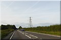
Pylon and cables crossing A420 near Henwood
Image: © David Smith
Taken: 24 Aug 2017
0.19 miles