IMAGES TAKEN NEAR TO
Norreys Road, OXFORD, OX2 9PU
Introduction
This page details the photographs taken nearby to Norreys Road, OX2 9PU by members of the Geograph project.
The Geograph project started in 2005 with the aim of publishing, organising and preserving representative images for every square kilometre of Great Britain, Ireland and the Isle of Man.

There are currently over 7.5m images from over14,400 individuals and you can help contribute to the project by visiting https://www.geograph.org.uk
Image Map
Images are licensed for reuse under creativecommons.org/licenses/by-sa/2.0
Notes
- Clicking on the map will re-center to the selected point.
- The higher the marker number, the further away the image location is from the centre of the postcode.
Image Listing (14 Images Found)
Images are licensed for reuse under creativecommons.org/licenses/by-sa/2.0
Image
Details
Distance
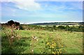
1
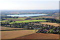
Norreys Road and Bertie Road at the top of Cumnor Hill
Farmoor Reservoir visible behind.
Image: © Dave Price
Taken: 12 Sep 2009
0.07 miles
6
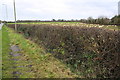
Hedge and footpath on NW side Cumnor Hill
The 3rd milestone from Oxford was sited here, but now believed to be lost: see http://www.bench-marks.org.uk/bm20335 for information about the stone and its benchmark
Image: © Roger Templeman
Taken: 1 Dec 2015
0.19 miles

10
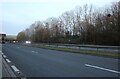
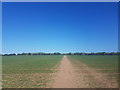
View From Chawley Lane
Chawley Lane starts off as a suburban street, has a few hundred metres as a country lane and then hits the A420 dual carriageway.
Nice views in between the roads and houses.
Image: © Des Blenkinsopp
Taken: 6 Sep 2012
0.23 miles