IMAGES TAKEN NEAR TO
Farmoor, OXFORD, OX2 9NX
Introduction
This page details the photographs taken nearby to OX2 9NX by members of the Geograph project.
The Geograph project started in 2005 with the aim of publishing, organising and preserving representative images for every square kilometre of Great Britain, Ireland and the Isle of Man.

There are currently over 7.5m images from over14,400 individuals and you can help contribute to the project by visiting https://www.geograph.org.uk
Image Map
Images are licensed for reuse under creativecommons.org/licenses/by-sa/2.0
Notes
- Clicking on the map will re-center to the selected point.
- The higher the marker number, the further away the image location is from the centre of the postcode.
Image Listing (14 Images Found)
Images are licensed for reuse under creativecommons.org/licenses/by-sa/2.0
Image
Details
Distance
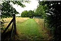
2
Footpath to the River Thames
The Countryside Walk stretches for 4.5 miles around Farmoor Reservoir.
Image: © Steve Daniels
Taken: 17 Aug 2013
0.03 miles
3
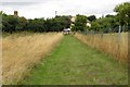
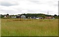
The footpath down to Lower Whitley Farm
The Countryside Walk stretches for 4.5 miles around Farmoor Reservoir.
Image: © Steve Daniels
Taken: 17 Aug 2013
0.05 miles
5
The footpath to Lower Whitley Farm
The Countryside Walk stretches for 4.5 miles around Farmoor Reservoir.
Image: © Steve Daniels
Taken: 17 Aug 2013
0.17 miles
6

Bench by the river
The bench is next to the Countryside Walk which stretches for 4.5 miles around Farmoor Reservoir.
Image: © Steve Daniels
Taken: 17 Aug 2013
0.17 miles
7
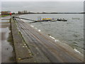
Farmoor Reservoir
Farmoor Reservoir II, small jetty at the Southern edge
Image: © Shaun Ferguson
Taken: 30 Dec 2009
0.18 miles
8
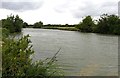
The River Thames
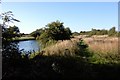
Looking upstream towards Bablock Hythe.
Image: © Steve Daniels
Taken: 17 Aug 2013
0.18 miles
9
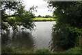
The River Thames
Looking from the Countryside Walk. The Countryside Walk stretches for 4.5 miles around Farmoor Reservoir.
Image: © Steve Daniels
Taken: 17 Aug 2013
0.18 miles
10
The Isis or Thames near Stanton Harcourt
A little further north, this path is marked "Towing Path". I hope there aren't so many trees in the way at that point.
Image: © Tom Pullman
Taken: 28 Aug 2005
0.20 miles