IMAGES TAKEN NEAR TO
Oxford Road, OXFORD, OX2 9NN
Introduction
This page details the photographs taken nearby to Oxford Road, OX2 9NN by members of the Geograph project.
The Geograph project started in 2005 with the aim of publishing, organising and preserving representative images for every square kilometre of Great Britain, Ireland and the Isle of Man.

There are currently over 7.5m images from over14,400 individuals and you can help contribute to the project by visiting https://www.geograph.org.uk
Image Map
Images are licensed for reuse under creativecommons.org/licenses/by-sa/2.0
Notes
- Clicking on the map will re-center to the selected point.
- The higher the marker number, the further away the image location is from the centre of the postcode.
Image Listing (35 Images Found)
Images are licensed for reuse under creativecommons.org/licenses/by-sa/2.0
Image
Details
Distance
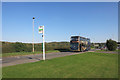
1
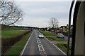
The main road through Farnmoor
This is the B4044 taken from the top of an S1 bus en route to Oxford.
Image: © Bill Boaden
Taken: 6 Apr 2010
0.03 miles
2
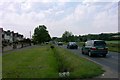
Farmoor
Farmoor consists mainly of houses situated on the western/southern side of the road from Cumnor to Eynsham. The hill on the right is Beacon Hill; the wood is Stroud Copse.
Image: © Tom Pullman
Taken: 27 May 2005
0.04 miles
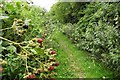
4
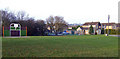
Recreation area, Farmoor
A play area safely away from the busy roads surrounding the village.
Image: © Jonathan Billinger
Taken: 19 Dec 2007
0.11 miles
8
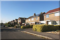
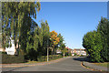
Houses in Meadow Close, Farmoor
Farmoor is a village of mostly recent housing with a suburban look to it.
Image: © Des Blenkinsopp
Taken: 12 Oct 2015
0.12 miles
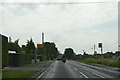
10
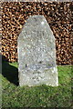
Witney 7 Oxford 4 milestone beside Oxford Road
The Ordnance Survey cut mark benchmark at the base of the stone is described on the Bench Mark Database at http://www.bench-marks.org.uk/bm73688
Image: © Roger Templeman
Taken: 24 Feb 2016
0.13 miles