IMAGES TAKEN NEAR TO
Cumnor Hill, OXFORD, OX2 9HY
Introduction
This page details the photographs taken nearby to Cumnor Hill, OX2 9HY by members of the Geograph project.
The Geograph project started in 2005 with the aim of publishing, organising and preserving representative images for every square kilometre of Great Britain, Ireland and the Isle of Man.

There are currently over 7.5m images from over14,400 individuals and you can help contribute to the project by visiting https://www.geograph.org.uk
Image Map
Images are licensed for reuse under creativecommons.org/licenses/by-sa/2.0
Notes
- Clicking on the map will re-center to the selected point.
- The higher the marker number, the further away the image location is from the centre of the postcode.
Image Listing (14 Images Found)
Images are licensed for reuse under creativecommons.org/licenses/by-sa/2.0
Image
Details
Distance
1
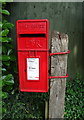
Elizabeth II postbox on Cumnor Hill
Postbox No. OX2 290.
See Image] for context.
Image: © JThomas
Taken: 15 Jul 2019
0.12 miles
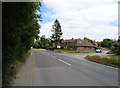
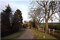
2
Cumnor Hill
Showing position of Postbox No. OX2 290.
See Image] for postbox.
Image: © JThomas
Taken: 15 Jul 2019
0.12 miles
3
Telephone Exchange, Cumnor Hill
Situated in Orchard Road, this TE dates from the GPO era and used to take the name Cumnor which is an adjacent village. It has the code SMCNR and provides telephone and broadband services to 2,768 residential and 107 non-residential premises in Cumnor and Cumnor Hill, plus Appleton, Eaton, Farmoor and Henwood nearby. A yellow grit salt bin and a red container can be seen in front of this building. The green notice refers to General Waste (not hazardous) for BT use only. This TE has the numbering range (01865) 86xxxx, the (01865) referring to the Oxford group of twenty TEs, and its postcode is OX2 9JG.
Image: © David Hillas
Taken: 9 Jun 2015
0.14 miles
4
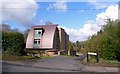
Breeches End
Unusual roofline on this property on Cumnor Hill.
Unusual name too.
Image: © Des Blenkinsopp
Taken: 17 Apr 2012
0.15 miles
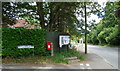
5
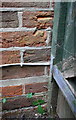
Benchmark, partly hidden by gatepost, on #139 Cumnor Hill
Ordnance Survey cut mark benchmark described on the Bench Mark Database at http://www.bench-marks.org.uk/bm70476
Image: © Roger Templeman
Taken: 23 Sep 2015
0.17 miles
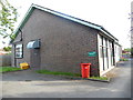
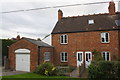
6
#139 Cumnor Hill
There is an OS benchmark Image on the left hand side of the house, just inside the wooden gate
Image: © Roger Templeman
Taken: 23 Sep 2015
0.17 miles
8
#19 Hurst Lane, 'Hurst View Cottage'
Image: © Roger Templeman
Taken: 23 Sep 2015
0.19 miles
9

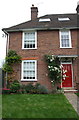
Barn Close, Cumnor Hill
A brand new development, but featuring many retro style details which exactly mimic some of the large and prosperous early 20C residences to be found nearby.
Image: © Des Blenkinsopp
Taken: 17 Apr 2012
0.19 miles