IMAGES TAKEN NEAR TO
Crawley, WITNEY, OX29 9TR
Introduction
This page details the photographs taken nearby to OX29 9TR by members of the Geograph project.
The Geograph project started in 2005 with the aim of publishing, organising and preserving representative images for every square kilometre of Great Britain, Ireland and the Isle of Man.

There are currently over 7.5m images from over14,400 individuals and you can help contribute to the project by visiting https://www.geograph.org.uk
Image Map
Images are licensed for reuse under creativecommons.org/licenses/by-sa/2.0
Notes
- Clicking on the map will re-center to the selected point.
- The higher the marker number, the further away the image location is from the centre of the postcode.
Image Listing (29 Images Found)
Images are licensed for reuse under creativecommons.org/licenses/by-sa/2.0
Image
Details
Distance
1
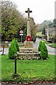
Crawley War Memorial, Foxburrow Lane, Crawley
Located on the small triangular village green, the memorial commemorates the dead of both World Wars.
Image: © P L Chadwick
Taken: 19 Nov 2011
0.03 miles
3
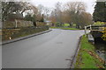
The NE end of Dry Lane
There is an OS benchmark Image on a stone at the base of the dry stone wall on the left hand side of the road, where the orange notebook is positioned
Image: © Roger Templeman
Taken: 25 Jan 2017
0.04 miles
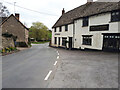
6
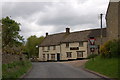
The Lamb Inn (2), Crawley
The Lamb Inn is a Grade II listed building. Part is 18th century, but according to the listing part is believed to probably date from the mid-17th century.
Image
Image
Image: © P L Chadwick
Taken: 19 Nov 2011
0.05 miles
7
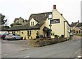
The Lamb Inn, Crawley
This restaurant offers a varied menu, but will not make a cup of tea!
Image: © Christina Burford
Taken: 23 May 2007
0.05 miles
9
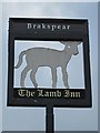
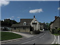
The Lamb Inn (3) - sign, Crawley
The sign indicates this was formerly a Brakspear's house.
The lamb is of great significance in Christianity, and the inn may have been given the name because of this connection. An alternative suggestion might be the local significance of the wool industry, particularly in nearby Witney, which was famous for its woollen blankets. In truth, often the reason why a pub or inn got its name has been lost with the passage of time.
Image
Image
Image: © P L Chadwick
Taken: 19 Nov 2011
0.05 miles
10
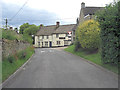
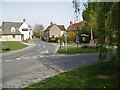
Leafield Road passes The Lamb
The pub is reputedly mid 17th C with English Heritage Building ID: 253590. See also: http://www.britishlistedbuildings.co.uk/en-253590-the-lamb-inn-crawley
Image: © Stuart Logan
Taken: 15 Jul 2012
0.06 miles