IMAGES TAKEN NEAR TO
Fordwells, WITNEY, OX29 9PT
Introduction
This page details the photographs taken nearby to OX29 9PT by members of the Geograph project.
The Geograph project started in 2005 with the aim of publishing, organising and preserving representative images for every square kilometre of Great Britain, Ireland and the Isle of Man.

There are currently over 7.5m images from over14,400 individuals and you can help contribute to the project by visiting https://www.geograph.org.uk
Image Map
Images are licensed for reuse under creativecommons.org/licenses/by-sa/2.0
Notes
- Clicking on the map will re-center to the selected point.
- The higher the marker number, the further away the image location is from the centre of the postcode.
Image Listing (13 Images Found)
Images are licensed for reuse under creativecommons.org/licenses/by-sa/2.0
Image
Details
Distance
1
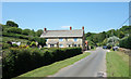
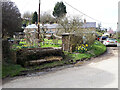
Lovegrove Holding, Fordwells
Lovegrove Holding or Lovegrove Farm depending which scale map you're looking at.
Image: © Des Blenkinsopp
Taken: 23 Jun 2020
0.02 miles
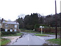
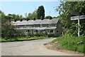
6
Approaching Fordwells
From Asthall Leigh.
Image: © andrew auger
Taken: 12 Dec 2009
0.10 miles
7
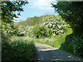
May blossom
Any colour you like as long as it's white. Hawthorn and Cow Parsley.
Image: © Robin Webster
Taken: 18 May 2014
0.17 miles
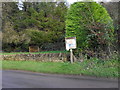
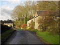
8
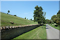
Someone likes cutting the grass
Immaculate verges along the lane out of Fordwells. Not only that, but the steep hillside field as well which can't have been easy. A true enthusiast, obviously.
Image: © Des Blenkinsopp
Taken: 23 Jun 2020
0.18 miles
9
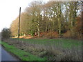
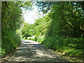
Woodland beside the road
Heading north away from Fordwells towards Shipton Under Wychwood.
Image: © andrew auger
Taken: 12 Dec 2009
0.19 miles