IMAGES TAKEN NEAR TO
Church End, WITNEY, OX29 7SR
Introduction
This page details the photographs taken nearby to Church End, OX29 7SR by members of the Geograph project.
The Geograph project started in 2005 with the aim of publishing, organising and preserving representative images for every square kilometre of Great Britain, Ireland and the Isle of Man.

There are currently over 7.5m images from over14,400 individuals and you can help contribute to the project by visiting https://www.geograph.org.uk
Image Map
Images are licensed for reuse under creativecommons.org/licenses/by-sa/2.0
Notes
- Clicking on the map will re-center to the selected point.
- The higher the marker number, the further away the image location is from the centre of the postcode.
Image Listing (24 Images Found)
Images are licensed for reuse under creativecommons.org/licenses/by-sa/2.0
Image
Details
Distance
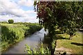
3
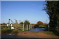
The Church from the River
The distinctive tower and roofline of St Giles' church visible in the distance from beside the River Windrush.
The invasive species Himalayan Balsam is doing well along the banks here.
Image: © Des Blenkinsopp
Taken: 22 Jul 2014
0.06 miles
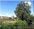
7

Mosaic triptych by the water, Standlake
One of a number of local mosaics in the area, part of the Windrush Trail. Local artist Ariana Windle designed them and local people made them using bits of crockery. See http://www.standlakepc.org.uk/mosaictrail.htm or http://www.oxfordshirecotswolds.org/xsdbimgs/Windrush%20Path%20Mosaic%20Trail%20Booklet.pdf for more information.
Image: © Neil Owen
Taken: 3 Sep 2011
0.08 miles
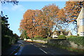
8
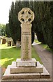
Standlake war memorial
The war memorial is in St Giles' churchyard.
Image: © Steve Daniels
Taken: 13 Jun 2013
0.08 miles
9
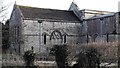
St Giles, Standlake: chancel and north transept
Showing two blocked mediaeval windows, the chancel one with flamboyant tracery.
Image: © Chris Brown
Taken: 24 Feb 2017
0.08 miles
10
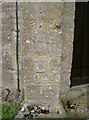
Benchmark and other features
The tower of St Giles church, Standlake, has a fine cutmark; alongside it are what appears to be the mere trace of a circle with a concrete plug near the centre, and above that a sundial of sorts.
See http://www.bench-marks.org.uk/bm39406 for the Benchamrk Database, and Image] for a look up the tower.
Image: © Neil Owen
Taken: 3 Sep 2011
0.09 miles