IMAGES TAKEN NEAR TO
Thornbury Road, WITNEY, OX29 4FW
Introduction
This page details the photographs taken nearby to Thornbury Road, OX29 4FW by members of the Geograph project.
The Geograph project started in 2005 with the aim of publishing, organising and preserving representative images for every square kilometre of Great Britain, Ireland and the Isle of Man.

There are currently over 7.5m images from over14,400 individuals and you can help contribute to the project by visiting https://www.geograph.org.uk
Image Map
Images are licensed for reuse under creativecommons.org/licenses/by-sa/2.0
Notes
- Clicking on the map will re-center to the selected point.
- The higher the marker number, the further away the image location is from the centre of the postcode.
Image Listing (15 Images Found)
Images are licensed for reuse under creativecommons.org/licenses/by-sa/2.0
Image
Details
Distance
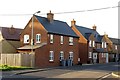
1
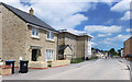
Thornbury Road, Eynsham
Part of a new neighbourhood on the edge of Eynsham west of Witney Road.
Image: © Des Blenkinsopp
Taken: 9 Jun 2021
0.01 miles
2
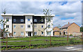
Housing, Thornbury Road
Part of a new housing development on the west side of Eynsham.
Image: © Des Blenkinsopp
Taken: 9 Jun 2021
0.01 miles
3
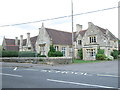
Eynsham: The Star public house
To be found on the west side of Witney Road, The Star is one of nine pubs in Eynsham.
Image: © Nigel Cox
Taken: 10 Feb 2006
0.05 miles
4
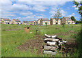
Grass, Logs and New Houses
Open land between Chilbridge Road and a new housing development west of Eynsham.
Image: © Des Blenkinsopp
Taken: 9 Jun 2021
0.08 miles
5
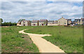
Path to the New Houses
A path from Chilbridge Road, an old bridleway, towards the houses on brand new Thornbury Road.
Image: © Des Blenkinsopp
Taken: 9 Jun 2021
0.09 miles
6
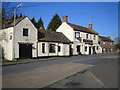
New houses in Star Close
The houses have been built on the site of The Star which stood on Witney Road.
Image: © Steve Daniels
Taken: 19 Mar 2014
0.12 miles
7
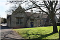
Bartholomew School building, Witney Road
This building has 'BOYS' carved over the doorway.
Image: © Roger Templeman
Taken: 12 Mar 2011
0.14 miles
8
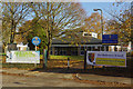
Bartholomew School, Eynsham
Bartholomew School is a mixed comprehensive for over 1275 students aged 11-18. The school's name commemorates John Bartholomew who left £350 for the education of boys in the village in 1700.
Image: © Stephen McKay
Taken: 14 Nov 2018
0.14 miles
9
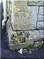
Benchmark on Bartholomew School, Witney Road
Ordnance Survey cut mark benchmark described on the Bench Mark Database at http://www.bench-marks.org.uk/bm37268. The building is shown at Image
Image: © Roger Templeman
Taken: 12 Mar 2011
0.14 miles