IMAGES TAKEN NEAR TO
Abraham Way, OX29 0AY
Introduction
This page details the photographs taken nearby to Abraham Way, OX29 0AY by members of the Geograph project.
The Geograph project started in 2005 with the aim of publishing, organising and preserving representative images for every square kilometre of Great Britain, Ireland and the Isle of Man.

There are currently over 7.5m images from over14,400 individuals and you can help contribute to the project by visiting https://www.geograph.org.uk
Image Map
Images are licensed for reuse under creativecommons.org/licenses/by-sa/2.0
Notes
- Clicking on the map will re-center to the selected point.
- The higher the marker number, the further away the image location is from the centre of the postcode.
Image Listing (19 Images Found)
Images are licensed for reuse under creativecommons.org/licenses/by-sa/2.0
Image
Details
Distance
1
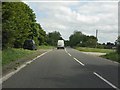
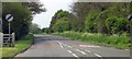
Burford Road approaching Minster Lovell
Image: © Peter Whatley
Taken: 21 May 2011
0.10 miles
2
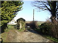
Folly Farm
With the track to Lower Field Farm alongside
Image: © Jonathan Billinger
Taken: 23 Jan 2007
0.11 miles
3
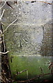
Benchmark on Folly Farm house
Ordnance Survey cut mark benchmark described on the Bench Mark Database at http://www.bench-marks.org.uk/bm81975
Image: © Roger Templeman
Taken: 7 Feb 2017
0.13 miles
4
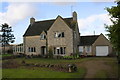
House at Folly Farm, Burford Road
There is an OS benchmark Image on the near corner, right hand face, of the main section of the house, beside the approach to the side door
Image: © Roger Templeman
Taken: 7 Feb 2017
0.13 miles
6
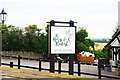
The Horse & Radish (2) - sign, Burford Road, Minster Lovell, Oxon
The sign for this country pub and dining business.
Image
Image: © P L Chadwick
Taken: 4 Jun 2020
0.15 miles
7
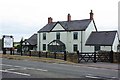
The Horse & Radish (1), Burford Road, Minster Lovell, Oxon
This country pub and restaurant has gone under several names in recent years, including The New Inn and The Dovecot. Now it is The Horse & Radish and describes itself as "Country pub & dining".
Image
Image
.
Image: © P L Chadwick
Taken: 4 Jun 2020
0.16 miles
8
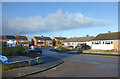
Wenrisc Drive, Minster Lovell
Wenrisc is an ancient spelling of Windrush, the local river, first recorded in AD 779.
Thanks to the Upper Windrush Local History Society for that information http://www.uwlhs.uk/loc_hdr.html
Seen here at the junction with Ripley Avenue.
Image: © Des Blenkinsopp
Taken: 15 Dec 2020
0.16 miles
9
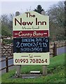
The New Inn (2) - sign, Burford Road, Minster Lovell
The sign is adjacent to Burford Road (the B4047). Update - the name was changed to "The Dovecote", but it is now "The Horse & Radish".
Image
Image
Image: © P L Chadwick
Taken: 19 Nov 2011
0.17 miles
