IMAGES TAKEN NEAR TO
Woodstock Road, OXFORD, OX2 8JX
Introduction
This page details the photographs taken nearby to Woodstock Road, OX2 8JX by members of the Geograph project.
The Geograph project started in 2005 with the aim of publishing, organising and preserving representative images for every square kilometre of Great Britain, Ireland and the Isle of Man.

There are currently over 7.5m images from over14,400 individuals and you can help contribute to the project by visiting https://www.geograph.org.uk
Image Map
Images are licensed for reuse under creativecommons.org/licenses/by-sa/2.0
Notes
- Clicking on the map will re-center to the selected point.
- The higher the marker number, the further away the image location is from the centre of the postcode.
Image Listing (8 Images Found)
Images are licensed for reuse under creativecommons.org/licenses/by-sa/2.0
Image
Details
Distance
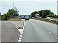
2
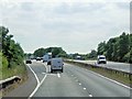
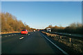
Southbound A34, Exit at Peartree Junction
Peartree Junction (aka Peartree Interchange) is the intersection of two major routes, the A34 and the A40, to the North-west of Oxford.
Image: © David Dixon
Taken: 17 Jul 2014
0.08 miles
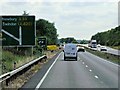
3
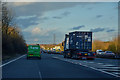
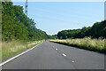
Cherwell : The A34
Looking along the A34 heading through the Cherwell District.
Image: © Lewis Clarke
Taken: 18 Mar 2019
0.11 miles
6
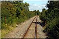
Footpath crossing by North Oxford Golf Course
Image: © Steve Daniels
Taken: 3 Sep 2009
0.22 miles
7
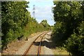
Trees line the track near Stratfield Brake
Image: © Steve Daniels
Taken: 3 Sep 2009
0.23 miles