IMAGES TAKEN NEAR TO
Water Eaton, OXFORD, OX2 8HD
Introduction
This page details the photographs taken nearby to Water Eaton, OX2 8HD by members of the Geograph project.
The Geograph project started in 2005 with the aim of publishing, organising and preserving representative images for every square kilometre of Great Britain, Ireland and the Isle of Man.

There are currently over 7.5m images from over14,400 individuals and you can help contribute to the project by visiting https://www.geograph.org.uk
Image Map
Images are licensed for reuse under creativecommons.org/licenses/by-sa/2.0
Notes
- Clicking on the map will re-center to the selected point.
- The higher the marker number, the further away the image location is from the centre of the postcode.
Image Listing (4 Images Found)
Images are licensed for reuse under creativecommons.org/licenses/by-sa/2.0
Image
Details
Distance
1
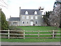
Middle Farm, Water Eaton
Farmhouse viewed from bridleway.
Image: © David Hawgood
Taken: 2 Mar 2007
0.01 miles
2
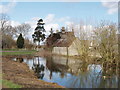
Middle farm buildings reflected in pond
There are three ponds near the farmhouse.
Image: © David Hawgood
Taken: 2 Mar 2007
0.02 miles
3
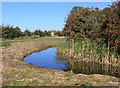
Pond at Middle Farm, Water Eaton
The tail end of one of several ponds near the farm. It has the look of a moat just here, but it's part of a natural short watercourse flowing into the Cherwell.
Image: © Des Blenkinsopp
Taken: 27 Sep 2018
0.06 miles
4
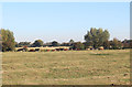
Ridge & Furrow at Water Eaton
In spite of being so close to Oxford, Water Eaton still seems a remote and unchanged sort of place. A farm, a large manor house and two or three houses, all with no public road access, are all that's there.
Image: © Des Blenkinsopp
Taken: 27 Sep 2018
0.20 miles