IMAGES TAKEN NEAR TO
The Old Coachyard, WITNEY, OX28 6JB
Introduction
This page details the photographs taken nearby to The Old Coachyard, OX28 6JB by members of the Geograph project.
The Geograph project started in 2005 with the aim of publishing, organising and preserving representative images for every square kilometre of Great Britain, Ireland and the Isle of Man.

There are currently over 7.5m images from over14,400 individuals and you can help contribute to the project by visiting https://www.geograph.org.uk
Image Map (Loading...)


Getting Data...Please wait
Leaflet Map data © OpenStreetMap
Images are licensed for reuse under creativecommons.org/licenses/by-sa/2.0
Notes
- Clicking on the map will re-center to the selected point.
- The higher the marker number, the further away the image location is from the centre of the postcode.
Image Listing (122 Images Found)
Images are licensed for reuse under creativecommons.org/licenses/by-sa/2.0
Image
Details
Distance
1
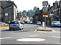
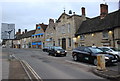
Bridge Street, Witney, Oxon
The picture was taken facing north-east from the junction of Bridge Street with Mill Street, Witney. It can be a traffic bottleneck at busy times.
Image: © Brian Robert Marshall
Taken: 8 Jun 2006
0.02 miles
2
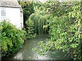
River Windrush, Bridge Street, Witney
The river is viewed from the bridge over it at Bridge Street, Witney facing west-north-west (upstream).
Image: © Brian Robert Marshall
Taken: 18 Sep 2006
0.02 miles
3
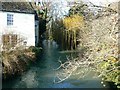
River Windrush at Bridge Street Witney
The view is upstream. There is a similar image for this square taken in September.
Image: © Brian Robert Marshall
Taken: 20 Dec 2006
0.02 miles
4
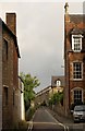
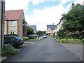
Gloucester Place, Witney
Little more than an alley leading off the High Street. At the far end can be seen Cape Terrace. "This long row of 22 stone cottages was built for workers in the blanket mills around 1865." http://witneyblanketstory.org.uk/WBP.asp?navigationPage=Sites&file=f:%5Cdomains%5Cmwsdata%5Cwitney%5C%5CWBPPLAC.MDF&record=Cape%20Terrace
Image: © Derek Harper
Taken: 28 Jun 2008
0.03 miles
5
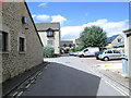
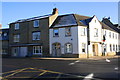
Gloucester Court Mews - off High Street
Image: © Betty Longbottom
Taken: 9 Aug 2013
0.03 miles
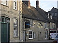
9
High St Witney
The prominent old building with the clock is Witney Blanket Hall. The road leads down to the bridge over the River Windrush, one of the main ributaries of the Thames. The road sign shows the roundabout for the A 4095 and the B 4047.
Image: © Nigel Mykura
Taken: 25 Feb 2017
0.05 miles
10
Junction of High Street and Witon Way
The building on the corner is occupied by Advance Housing and Support Ltd, a national charitable organisation, providing high quality housing, support, and employment services for thousands of people with learning disabilities.
Image: © Roger Templeman
Taken: 29 Dec 2014
0.06 miles