IMAGES TAKEN NEAR TO
Snowshill Drive, WITNEY, OX28 5GT
Introduction
This page details the photographs taken nearby to Snowshill Drive, OX28 5GT by members of the Geograph project.
The Geograph project started in 2005 with the aim of publishing, organising and preserving representative images for every square kilometre of Great Britain, Ireland and the Isle of Man.

There are currently over 7.5m images from over14,400 individuals and you can help contribute to the project by visiting https://www.geograph.org.uk
Image Map (Loading...)


Getting Data...Please wait
Leaflet Map data © OpenStreetMap
Images are licensed for reuse under creativecommons.org/licenses/by-sa/2.0
Notes
- Clicking on the map will re-center to the selected point.
- The higher the marker number, the further away the image location is from the centre of the postcode.
Image Listing (21 Images Found)
Images are licensed for reuse under creativecommons.org/licenses/by-sa/2.0
Image
Details
Distance
2
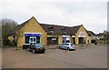
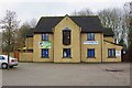
Shops at 1-3 Edington Square, Witney, Oxon
A small parade of shops in Edington Square, off Edington Road, to primarily serve the surrounding Deer Park Estate. At no.3 is a branch of Boots Pharmacy; at no.2 is Peking Chef, a Chinese food takeaway and at no.1 is a Tesco Express convenience store, one of several they operate in the town.
Image: © P L Chadwick
Taken: 18 Feb 2018
0.12 miles
4
Footpath from Edington Square to Valence Crescent, Witney, Oxon
A footpath in the Deer Park Estate linking the square to one of the estate's main roads.
Image: © P L Chadwick
Taken: 18 Feb 2018
0.13 miles
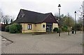
5
Stepping Stones, 5 Edington Square, Witney, Oxon
A day nursery and nursery school on the Deer Park Estate in Witney.
Image: © P L Chadwick
Taken: 18 Feb 2018
0.14 miles
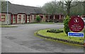
6
The former Deer Park Medical Centre, 6 Edington Square, Witney, Oxon
This was one of a number of GP practices in the town and was built primarily to serve the residents of the Deer Park Estate and nearby. It closed on the 27th March 2017 due to circumstances too complicated to go into here. The 4,300 or so patients were obliged to register with other practices but it appears a sizeable proportion of them did not do so (as at a few months ago). The closure caused great local controversy.
Image: © P L Chadwick
Taken: 18 Feb 2018
0.15 miles
7
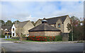
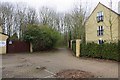
Small Building on the Corner
These little buildings with ventilated roofs are to be seen all around the area. I am guessing they are bin sheds or something like that.
Image: © Des Blenkinsopp
Taken: 15 Oct 2020
0.16 miles
8
Entrance to West Witney Primary School & Nursery, Witney, Oxon
This entrance is from Edington Road.
Image
Image: © P L Chadwick
Taken: 18 Feb 2018
0.16 miles
9
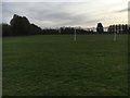
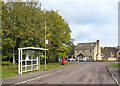
Football Pitch
Football pitch on the West Witney sports playing field
Image: © Shaun Ferguson
Taken: 9 Mar 2019
0.17 miles
10
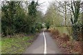
Footpath & cycleway to Deer Park Road, Witney, Oxon
This connects Edington Road to Deer Park Road. It passes Ralegh Crescent Recreation & Play Park, which is behind the trees on the left. Later it passes Deer Park Field.
Image: © P L Chadwick
Taken: 18 Feb 2018
0.17 miles