IMAGES TAKEN NEAR TO
St. Marys Mead, WITNEY, OX28 4EZ
Introduction
This page details the photographs taken nearby to St. Marys Mead, OX28 4EZ by members of the Geograph project.
The Geograph project started in 2005 with the aim of publishing, organising and preserving representative images for every square kilometre of Great Britain, Ireland and the Isle of Man.

There are currently over 7.5m images from over14,400 individuals and you can help contribute to the project by visiting https://www.geograph.org.uk
Image Map
Images are licensed for reuse under creativecommons.org/licenses/by-sa/2.0
Notes
- Clicking on the map will re-center to the selected point.
- The higher the marker number, the further away the image location is from the centre of the postcode.
Image Listing (263 Images Found)
Images are licensed for reuse under creativecommons.org/licenses/by-sa/2.0
Image
Details
Distance
1
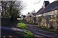
Farm Mill Lane, Witney, Oxon
This section of the lane is not open to motor vehicles. In this direction the lane is heading for Church Green.
Image: © P L Chadwick
Taken: 28 Mar 2016
0.04 miles
2
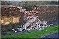
Partially collapsed wall, Farm Mill Lane, Witney, Oxon
Originally a dry stone wall, it looks as if some cement was added between a few of the bricks at some stage. The wall is probably quite old, the lane it adjoins having originally linked the town centre with a large mill and possibly earlier ones.
Image: © P L Chadwick
Taken: 28 Mar 2016
0.05 miles
3
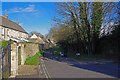
Farm Mill Lane, Witney, Oxon
In the foreground is an area for turning motor vehicles, as they can proceed no further along the lane. In this direction the lane leads to Witan Way. On the right is a dog waste bin.
Image: © P L Chadwick
Taken: 28 Mar 2016
0.05 miles
4
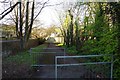
Farm Mill Lane, Witney, Oxon
The lane in this direction is heading for Witan Way, which is in the far distance.
Image: © P L Chadwick
Taken: 28 Mar 2016
0.07 miles
5
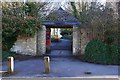
Entrance to Sainsbury's from Farm Mill Lane, Witney, Oxon
The arch leads to the car park and Sainsbury's supermarket.
Image: © P L Chadwick
Taken: 28 Mar 2016
0.07 miles
6
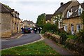
Entrance to Farm Mill Lane, Witney, Oxon
This is the Witan Way entrance to the main part of Farm Mill Lane, which in this direction is heading for Church Green. Witan Way is a fairly modern road and its construction split the lane into two sections. A small section is on the other side of Witan Way and leads to the former mill, which has been converted into apartments.
Image: © P L Chadwick
Taken: 28 Mar 2016
0.08 miles

8
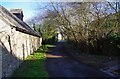
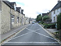
Farm Mill Lane, Witney, Oxon
This road off Church Green has many attractive old houses in Cotswold stone. According to the OS map there is also a public bridleway running along its whole length.
Image: © P L Chadwick
Taken: 17 Oct 2015
0.10 miles
10
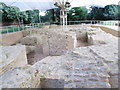
Remains of Bishop's Palace - off Church Green
Remains of Palace built for Bishop of Winchester in 12th Century.
Image: © Betty Longbottom
Taken: 9 Aug 2013
0.11 miles