IMAGES TAKEN NEAR TO
Avenue One, WITNEY, OX28 4BZ
Introduction
This page details the photographs taken nearby to Avenue One, OX28 4BZ by members of the Geograph project.
The Geograph project started in 2005 with the aim of publishing, organising and preserving representative images for every square kilometre of Great Britain, Ireland and the Isle of Man.

There are currently over 7.5m images from over14,400 individuals and you can help contribute to the project by visiting https://www.geograph.org.uk
Image Map (Loading...)


Getting Data...Please wait
Leaflet Map data © OpenStreetMap
Images are licensed for reuse under creativecommons.org/licenses/by-sa/2.0
Notes
- Clicking on the map will re-center to the selected point.
- The higher the marker number, the further away the image location is from the centre of the postcode.
Image Listing (95 Images Found)
Images are licensed for reuse under creativecommons.org/licenses/by-sa/2.0
Image
Details
Distance
1

Emma's Dike, Witney, Oxon
Emma's Dike is the name of this stream or watercourse which connects with the River Windrush. On at least one modern map it is named Em's Ditch, which seems rather unlikely. Here is it passing between units on the Witney Industrial Estate. The name appears to come from a prominent historical Royal figure of the 11th century. Queen Emma was first married to King Ethelread ("the Unready" and following his death, she was married to the Dane King Knut (Canute). One of her sons by her first marriage became King Edward the Confessor.
Queen Emma owned land in Oxfordshire and in 1044 she granted the Bishop of Winchester an estate in Witney and this was confirmed in the Domesday Book. There is a street in Witney named Queen Emma's Dike.
Image: © P L Chadwick
Taken: 13 Mar 2016
0.02 miles
3
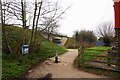
Footpath & cycleway connecting Avenue Two to Witney Lake, Witney, Oxon
The footpath & cycleway go through a tunnel under the A40 road. The entrance to this can be seen in the distance.
Image: © P L Chadwick
Taken: 13 Mar 2016
0.05 miles
4
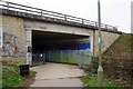
Entrance to tunnel under A40 road, Witney, Oxon
This tunnel leads to Witney Lake, the circular footpath running around it and links to other paths and cycle routes.
Image: © P L Chadwick
Taken: 13 Mar 2016
0.05 miles
5
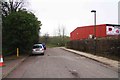
The southern end of Avenue Two, Witney, Oxon
Around the corner, at the bottom of this road, there is a footpath/cycleway which passes through a tunnel under the A40 road and leads to Witney Lake.
Image
Image: © P L Chadwick
Taken: 13 Mar 2016
0.06 miles
6

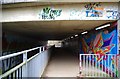
Graffito in the Emma's Dike foot tunnel under A40
I don't know when this was written but I'm guessing it was while David Cameron was both MP for Witney and prime minister.
Image: © Chris Brown
Taken: 30 Aug 2017
0.06 miles
7
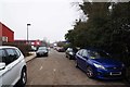
Avenue Two, Witney, Oxon
Avenue Two is one of the roads on Witney Trading Estate and is a turning off Station Lane. This view is looking in the direction of Station Lane.
Image
Image: © P L Chadwick
Taken: 13 Mar 2016
0.07 miles
8
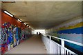
Tunnel under the A40 road, Witney, Oxon
This tunnel passes under the busiest road around Witney, the A40. It carries on the left a footpath and cycleway, and on the right side of the white railings, is a channel at a lower level for Emma's Dike. See Image for more information. This view is looking in the direction of Witney Lake.
Image: © P L Chadwick
Taken: 13 Mar 2016
0.07 miles
9
Entrance to tunnel under A40 road, Witney, Oxon
This is the entrance on the Witney Lake side. The tunnel gives access to Witney Industrial Estate and the town centre via Avenue Two. On the left of the railings, at a much lower level, is a channel carrying Emma's Dike under the road. See Image for more information. To the right is a footpath and cycleway.
Image: © P L Chadwick
Taken: 13 Mar 2016
0.07 miles
10
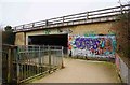
Approach to the entrance to the tunnel under A40 road, Witney, Oxon
This is the approach from the Witney Lake side of the tunnel, which carries Emma's Dyke and a footpath and cycleway under the A40 road. The footpath and cycleway come out at the end of Avenue Two, and this provides a route to the town centre.
Image: © P L Chadwick
Taken: 13 Mar 2016
0.07 miles