IMAGES TAKEN NEAR TO
Station Lane, WITNEY, OX28 4BA
Introduction
This page details the photographs taken nearby to Station Lane, OX28 4BA by members of the Geograph project.
The Geograph project started in 2005 with the aim of publishing, organising and preserving representative images for every square kilometre of Great Britain, Ireland and the Isle of Man.

There are currently over 7.5m images from over14,400 individuals and you can help contribute to the project by visiting https://www.geograph.org.uk
Image Map (Loading...)


Getting Data...Please wait
Leaflet Map data © OpenStreetMap
Images are licensed for reuse under creativecommons.org/licenses/by-sa/2.0
Notes
- Clicking on the map will re-center to the selected point.
- The higher the marker number, the further away the image location is from the centre of the postcode.
Image Listing (292 Images Found)
Images are licensed for reuse under creativecommons.org/licenses/by-sa/2.0
Image
Details
Distance
1

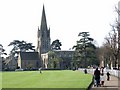
Houses within Churchyard of St Mary's Church
Image: © Betty Longbottom
Taken: 9 Aug 2013
0.01 miles
2
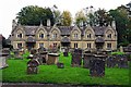
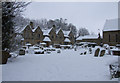
Almshouses, Church Green, Witney, Oxon
These almshouses are at the southern end of Church Green, overlooking part of the graveyard of St. Mary's Church. These almshouses were originally built in 1724 for six widows of blanketmakers. They were rebuilt in 1868 by William Wilkinson of Oxford in Gothic style.
Image: © P L Chadwick
Taken: 17 Oct 2015
0.01 miles
3
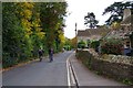
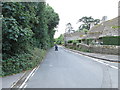
Station Lane, Witney, Oxon
The road is now one-way. It used to give access to Witney's original railway station which later became the goods station. It closed for goods in November 1970, passenger services to Witney having ended some years previously. There has recently been some discussion about the need to re-instate some kind of rail link to Witney and ideally beyond to Carterton. Possibilities suggested include some kind of light rail or tram-train. Whether anything will actually happen remains to be seen.
Image: © P L Chadwick
Taken: 17 Oct 2015
0.01 miles
4
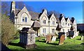
Almshouses, Witney, Oxon
This group of Almshouses called 'The Holloways' were donated by Mr John Holloway during the 18th century. They were refurbished in 1868. They are situated to the East of the church of St Mary the Virgin, refer to picture Image
Image: © Len Williams
Taken: 25 Mar 2017
0.01 miles
6
Cottages next to St Mary's Church
Cottages and grave stones next to St Mary's Church, in Witney.
Image: © Miranda Hodgson
Taken: 6 Jan 2010
0.01 miles
7
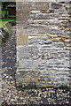
Benchmark on St Mary's Church
Ordnance Survey cut mark benchmark described on the Bench Mark Database at http://www.bench-marks.org.uk/bm37257
Image: © Roger Templeman
Taken: 10 Mar 2011
0.01 miles
8
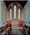
St Mary, Witney, East Window and Altar
This is a view of the altar and the East window of the church of St Mary, Witney. For a view of the church from the green refer to picture Image
Image: © Len Williams
Taken: 25 Mar 2017
0.01 miles
9

Moon over St Mary the Virgin church, Witney
Taken shortly before 0800 from the car park of Sainsbury's supermarket, the church clock is remarkably accurate.
Image: © Brian Robert Marshall
Taken: 4 Jan 2007
0.02 miles