IMAGES TAKEN NEAR TO
Oxlease, WITNEY, OX28 3QY
Introduction
This page details the photographs taken nearby to Oxlease, OX28 3QY by members of the Geograph project.
The Geograph project started in 2005 with the aim of publishing, organising and preserving representative images for every square kilometre of Great Britain, Ireland and the Isle of Man.

There are currently over 7.5m images from over14,400 individuals and you can help contribute to the project by visiting https://www.geograph.org.uk
Image Map (Loading...)


Getting Data...Please wait
Leaflet Map data © OpenStreetMap
Images are licensed for reuse under creativecommons.org/licenses/by-sa/2.0
Notes
- Clicking on the map will re-center to the selected point.
- The higher the marker number, the further away the image location is from the centre of the postcode.
Image Listing (73 Images Found)
Images are licensed for reuse under creativecommons.org/licenses/by-sa/2.0
Image
Details
Distance
1
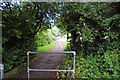
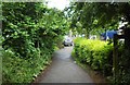
Footpath from Mud Lane to Oxlease, Cogges, Witney, Oxon
A short footpath linking Mud Lane with the residential road known as Oxlease.
Image: © P L Chadwick
Taken: 27 May 2017
0.03 miles
2
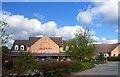
Tesco's in Cogges
Apart from the Church, Manor House and Farm Museum most of Cogges is a modern suburb, with a Tesco's.
Image: © Des Blenkinsopp
Taken: 15 Apr 2012
0.04 miles
3

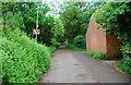
Gas installation adjacent to Mud Lane, Cogges, Witney, Oxon
This is some kind of gas supply installation, presumably related to nearby housing. A notice gives a telephone number to call if you are proposing to undertake work within a stated distance, or think you can smell gas.
Image: © P L Chadwick
Taken: 27 May 2017
0.05 miles

5
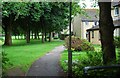
Footpath off Mud Lane, Cogges, Witney, Oxon
This footpath goes all the way around the edge of Oxlease Park, which can be seen on the left. The houses on the right are in the residential road known as Oxlease.
Image: © P L Chadwick
Taken: 27 May 2017
0.05 miles
6
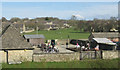
Cogges Farm and Wadard's Meadow
Cogges' first owner, a Norman knight called Wadard, has been commemorated by naming a local housing estate and open space Wadard's Meadow.
This view from the upper storey of the Manor Farm Museum shows the restaurant (both out and indoor) and the children's playground.
Image: © Rabbi WP Thinrod
Taken: 30 Mar 2008
0.06 miles
7
Footpath to Cogges Hill Road from Mud Lane, Cogges, Witney, Oxon
Cogges Hill Road has several branches and this footpath leads to one of them from Mud Lane.
Image: © P L Chadwick
Taken: 27 May 2017
0.06 miles
8
Mud Lane cycleway & footpath, Cogges, Witney, Oxon
Just behind the camera position Mud Lane ceases to be a road and continues as a cycleway and footpath. It passes through the Cogges Estate and eventually arrives at Blakes Avenue, on the edge of the town.
Image: © P L Chadwick
Taken: 27 May 2017
0.06 miles
9
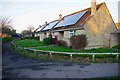
Solar panels on bungalows in Wadard's Meadow, Witney, Oxon
The three bungalows nearest the camera have large solar panels on their rooves (or roofs, if you prefer). The large housing estate known as Wadard's Meadow is named after a Norman knight who apparently came over to England with William the Conqueror. Wadard held lands in Oxfordshire and elsewhere and is depicted on the Bayeux Tapestry. But little else seems to be known about him.
Image: © P L Chadwick
Taken: 19 Jan 2020
0.07 miles
10
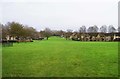
Open space near Mud Lane, Cogges, Witney, Oxon
There are a few paths around the edges and across this open space. The housing on the left is in Wadards Meadow. That on the right is in Oxlease.
Image: © P L Chadwick
Taken: 31 Jan 2016
0.07 miles