IMAGES TAKEN NEAR TO
West End Industrial Estate, West End, WITNEY, OX28 1UB
Introduction
This page details the photographs taken nearby to West End Industrial Estate, West End, OX28 1UB by members of the Geograph project.
The Geograph project started in 2005 with the aim of publishing, organising and preserving representative images for every square kilometre of Great Britain, Ireland and the Isle of Man.

There are currently over 7.5m images from over14,400 individuals and you can help contribute to the project by visiting https://www.geograph.org.uk
Image Map (Loading...)


Getting Data...Please wait
Leaflet Map data © OpenStreetMap
Images are licensed for reuse under creativecommons.org/licenses/by-sa/2.0
Notes
- Clicking on the map will re-center to the selected point.
- The higher the marker number, the further away the image location is from the centre of the postcode.
Image Listing (91 Images Found)
Images are licensed for reuse under creativecommons.org/licenses/by-sa/2.0
Image
Details
Distance
1
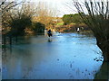
Chivalry is not dead
The River Windrush in Witney has burst its banks at this point and flooded the adjacent field.
Image: © Brian Robert Marshall
Taken: 10 Jan 2007
0.06 miles
2
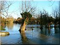
Floodwaters, near Riverside Gardens and the River Windrush, Witney
Several areas in and around Witney experienced flooding on 10 January 2007. This is one of them.
Image: © Brian Robert Marshall
Taken: 10 Jan 2007
0.07 miles
3
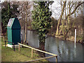
Witney Flood Warning Station
The Environment Agency flood warning station on the River Windrush gives early warning of rising water levels that might cause flooding in this low lying part of town.
The white spots on this pic. are snow.
Image: © Des Blenkinsopp
Taken: 10 Feb 2010
0.07 miles
4
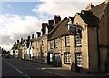
The House of Windsor, Witney
Looking the other way along Image past the old pub.
Image: © Derek Harper
Taken: 28 Jun 2008
0.08 miles
5
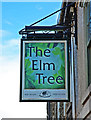
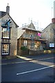
The Elm Tree (2) - sign, 21 West End, Witney, Oxon
A free house, although it sells the beers of local brewer the Wychwood Brewery.
Image
Image: © P L Chadwick
Taken: 1 Feb 2014
0.08 miles
6
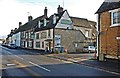
The Elm Tree (1), 21 West End, Witney, Oxon
A traditional public house and free of brewery ties. It is the only one currently open in West End. The building is Grade II listed. Built early in the 18th century originally as a private house but later became a pub. Some 20th century alterations.
Image
Image: © P L Chadwick
Taken: 1 Feb 2014
0.08 miles
7
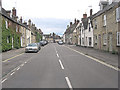
West End passes The Elm Tree
B4022 Hailey Road becomes West End and most of its buildings are listed properties. The Elm Tree was originally constructed as a house but is now a Grade II listed pub with English Heritage Building ID: 398568. See also:
http://www.britishlistedbuildings.co.uk/en-398568-the-elm-tree-public-house-21-witney
Image: © Stuart Logan
Taken: 15 Jul 2012
0.09 miles
8
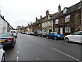
West End, Witney
West End is a main thoroughfare in Witney
Image: © Bikeboy
Taken: 7 Apr 2014
0.09 miles
9
Elim Christian Fellowship, West End, Witney, Oxon
The Elim Christian Fellowship is an Elim Pentecostal Church. The building dates from 1881 when it was built for use as a Church of England School. It then was taken over by the Catholic Church as a chapel. In 1975 it was purchased by the Elim Movement who have been worshiping there since that time. Currently the exterior of the building appears to be undergoing renovation.
Image: © P L Chadwick
Taken: 1 Feb 2014
0.09 miles
10
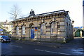
#28 Bridge Street, former government offices
There is an OS benchmark Image on the front face of the right hand corner of the building
Image: © Roger Templeman
Taken: 29 Dec 2014
0.09 miles