IMAGES TAKEN NEAR TO
Stratton Audley, BICESTER, OX27 9RF
Introduction
This page details the photographs taken nearby to OX27 9RF by members of the Geograph project.
The Geograph project started in 2005 with the aim of publishing, organising and preserving representative images for every square kilometre of Great Britain, Ireland and the Isle of Man.

There are currently over 7.5m images from over14,400 individuals and you can help contribute to the project by visiting https://www.geograph.org.uk
Image Map (Loading...)


Getting Data...Please wait
Leaflet Map data © OpenStreetMap
Images are licensed for reuse under creativecommons.org/licenses/by-sa/2.0
Notes
- Clicking on the map will re-center to the selected point.
- The higher the marker number, the further away the image location is from the centre of the postcode.
Image Listing (7 Images Found)
Images are licensed for reuse under creativecommons.org/licenses/by-sa/2.0
Image
Details
Distance
1

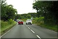
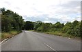
A4421 towards Buckingham
A Roman route.
Image: © Robin Webster
Taken: 22 Aug 2020
0.06 miles
3
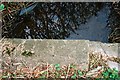
Stratton Audley, Rivet benchmark on culvert beside A4421
1962 Ordnance Survey rivet benchmark on concrete slab forming top of culvert on SE side of the A4421 north of Bicester. The rivet is accompanied by the usual arrow cutmarks, somewhat shallow in the concrete. The mark was levelled at a height of 85.7445m above Newlyn datum. Further details of this benchmark and other nearby ones may be found at http://bench-marks.org.uk/bm33953.
Image: © Roger Templeman
Taken: 12 Apr 2010
0.09 miles
5
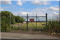
The new back entrance to RAF Bicester airfield
It was moved from further along the road a year or two ago.
Image: © David Howard
Taken: 8 Jun 2019
0.12 miles