IMAGES TAKEN NEAR TO
Stoke Lyne Road, BICESTER, OX27 9AU
Introduction
This page details the photographs taken nearby to Stoke Lyne Road, OX27 9AU by members of the Geograph project.
The Geograph project started in 2005 with the aim of publishing, organising and preserving representative images for every square kilometre of Great Britain, Ireland and the Isle of Man.

There are currently over 7.5m images from over14,400 individuals and you can help contribute to the project by visiting https://www.geograph.org.uk
Image Map
Images are licensed for reuse under creativecommons.org/licenses/by-sa/2.0
Notes
- Clicking on the map will re-center to the selected point.
- The higher the marker number, the further away the image location is from the centre of the postcode.
Image Listing (47 Images Found)
Images are licensed for reuse under creativecommons.org/licenses/by-sa/2.0
Image
Details
Distance
3
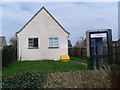
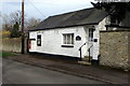
Stratton Audley Telephone Exchange, Oxon
Situated in Cherry Street, this TE dates from the GPO era and has the code SMSAY. It provides telephone and broadband services to 996 residential and 88 non-residential premises in Stratton Audley plus Fringford, Hethe, Marsh Gibbon and Poundon nearby. The KX300 phone kiosk in front of the TE still has the former BT Piper logo on it, plus the notice that coins are not accepted here. This TE has the numbering ranges (01869) 277xxx, 278xxx, the (01869) referring to the Bicester group of ten TEs and its postcode is OX27 9AA. Update: the KX300 telephone kiosk has since been removed from this location.
Image: © David Hillas
Taken: 9 Apr 2010
0.08 miles
5
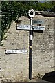
Old Direction Sign - Signpost, Church Street, Stratton Audley
Annulus finial - 3 arms; Oxford CC halo by the UC road, in parish of Stratton Audley (Cherwell District), junction of Church Street and Bicester Road, footway.
Surveyed
Milestone Society National ID: OX_SP6026A.
Image: © Milestone Society
Taken: Unknown
0.13 miles
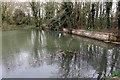
6

Stream by Mill Road
So probably the mill stream I imagine
Image: © Philip Jeffrey
Taken: 10 Apr 2016
0.16 miles
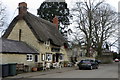
8
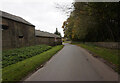
Mill Lane, Stratton Audley
Another view of Mill Lane, Stratton Audley. This time, from further down Mill Lane for a longer rural scene.
Image: © Kurt C
Taken: 3 Jun 2009
0.17 miles