IMAGES TAKEN NEAR TO
Gold Mews, BICESTER, OX27 8BS
Introduction
This page details the photographs taken nearby to Gold Mews, OX27 8BS by members of the Geograph project.
The Geograph project started in 2005 with the aim of publishing, organising and preserving representative images for every square kilometre of Great Britain, Ireland and the Isle of Man.

There are currently over 7.5m images from over14,400 individuals and you can help contribute to the project by visiting https://www.geograph.org.uk
Image Map
Images are licensed for reuse under creativecommons.org/licenses/by-sa/2.0
Notes
- Clicking on the map will re-center to the selected point.
- The higher the marker number, the further away the image location is from the centre of the postcode.
Image Listing (15 Images Found)
Images are licensed for reuse under creativecommons.org/licenses/by-sa/2.0
Image
Details
Distance
1
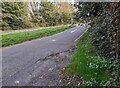
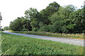
Parking area on Banbury Road, Caversfield
Image: © David Howard
Taken: 17 Oct 2021
0.05 miles
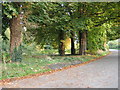
3

Parking area on Banbury Road, Caversfield
Image: © David Howard
Taken: 17 Oct 2021
0.10 miles
5
The B4100, Caversfield
The housing estate has just been built in fields.
Image: © David Howard
Taken: 11 Oct 2020
0.13 miles
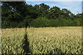
7
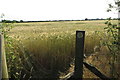
Footpath to Bucknell
Not one anyone takes from the look of the wheat though.
Image: © Philip Jeffrey
Taken: 1 Jul 2018
0.15 miles
8
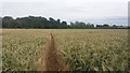
Path heading to the B4100
From Bucknell the path heading to the B4100
Image: © Shaun Ferguson
Taken: 3 Jul 2020
0.15 miles
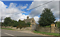
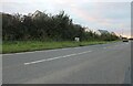
10
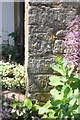
Benchmark on Northside Lodge
Ordnance survey cut mark benchmark described on the Bench Mark Database at http://www.bench-marks.org.uk/bm58192
Image: © Roger Templeman
Taken: 9 Jun 2014
0.16 miles