IMAGES TAKEN NEAR TO
Hethe, BICESTER, OX27 8AW
Introduction
This page details the photographs taken nearby to OX27 8AW by members of the Geograph project.
The Geograph project started in 2005 with the aim of publishing, organising and preserving representative images for every square kilometre of Great Britain, Ireland and the Isle of Man.

There are currently over 7.5m images from over14,400 individuals and you can help contribute to the project by visiting https://www.geograph.org.uk
Image Map
Images are licensed for reuse under creativecommons.org/licenses/by-sa/2.0
Notes
- Clicking on the map will re-center to the selected point.
- The higher the marker number, the further away the image location is from the centre of the postcode.
Image Listing (16 Images Found)
Images are licensed for reuse under creativecommons.org/licenses/by-sa/2.0
Image
Details
Distance
1
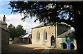
Behind Holy Trinity Church
Round the back of the church is this small hall or parish room.
Image: © Des Blenkinsopp
Taken: 12 Sep 2015
0.01 miles
2
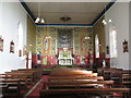
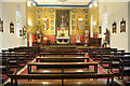
Holy Trinity church, interior
A very traditional interior which seems to have escaped many of the reforms of the 1960s.
Image: © Jonathan Thacker
Taken: 31 Oct 2016
0.01 miles
4
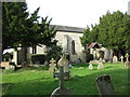
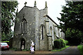
Holy Trinity Roman Catholic church, Hethe
Shows the east (ritually south) side. Date from 1832.
Image: © Jonathan Thacker
Taken: 31 Oct 2016
0.01 miles
6
Holy Trinity RC church, Hethe
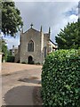
On the outskirts of the village.
Image: © Julian Dowse
Taken: 1 Jun 2008
0.02 miles
7
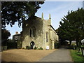
Holy Trinity Roman Catholic church, Hethe
Dates from 1832.
Image: © Jonathan Thacker
Taken: 31 Oct 2016
0.02 miles
8
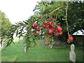
Yew berries
In the churchyard of Holy Trinity, Hethe.
Image: © Jonathan Thacker
Taken: 31 Oct 2016
0.02 miles
9
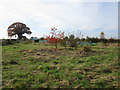
Allotments, Hethe
Some distance from the village but close to Holy Trinity church.
Image: © Jonathan Thacker
Taken: 31 Oct 2016
0.04 miles
10
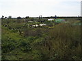
Allotments near Hethe
Allotments by Hardwick Road near Hethe
Image: © Shaun Ferguson
Taken: 1 Oct 2011
0.06 miles