IMAGES TAKEN NEAR TO
Newton Morrell, BICESTER, OX27 8AG
Introduction
This page details the photographs taken nearby to OX27 8AG by members of the Geograph project.
The Geograph project started in 2005 with the aim of publishing, organising and preserving representative images for every square kilometre of Great Britain, Ireland and the Isle of Man.

There are currently over 7.5m images from over14,400 individuals and you can help contribute to the project by visiting https://www.geograph.org.uk
Image Map
Images are licensed for reuse under creativecommons.org/licenses/by-sa/2.0
Notes
- Clicking on the map will re-center to the selected point.
- The higher the marker number, the further away the image location is from the centre of the postcode.
Image Listing (13 Images Found)
Images are licensed for reuse under creativecommons.org/licenses/by-sa/2.0
Image
Details
Distance
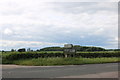
2
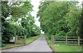
Private track to houses in Newton Morrell
Image: © David Howard
Taken: 8 Jun 2019
0.17 miles
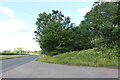
3
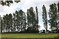
Poplar trees in Newton Morrell
These are usually planted as windbreaks
Image: © David Howard
Taken: 8 Jun 2019
0.18 miles
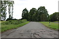
4
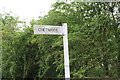
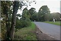
Fingerpost to Chetwode, Newton Morrell
On a sharp bend, if you don't turn left you end up on a private track.
Image: © David Howard
Taken: 8 Jun 2019
0.19 miles
5
Roman Road at the junction of the A4421
Image: © David Howard
Taken: 13 Jun 2020
0.20 miles
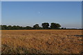
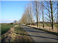
10
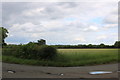
Single track road to Chetwode
From Newton Morrell
Image: © David Howard
Taken: 8 Jun 2019
0.21 miles