IMAGES TAKEN NEAR TO
Ardley Road, BICESTER, OX27 7AD
Introduction
This page details the photographs taken nearby to Ardley Road, OX27 7AD by members of the Geograph project.
The Geograph project started in 2005 with the aim of publishing, organising and preserving representative images for every square kilometre of Great Britain, Ireland and the Isle of Man.

There are currently over 7.5m images from over14,400 individuals and you can help contribute to the project by visiting https://www.geograph.org.uk
Image Map (Loading...)


Getting Data...Please wait
Leaflet Map data © OpenStreetMap
Images are licensed for reuse under creativecommons.org/licenses/by-sa/2.0
Notes
- Clicking on the map will re-center to the selected point.
- The higher the marker number, the further away the image location is from the centre of the postcode.
Image Listing (17 Images Found)
Images are licensed for reuse under creativecommons.org/licenses/by-sa/2.0
Image
Details
Distance
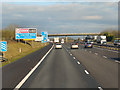
1
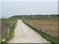
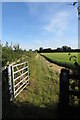
Bridleway to Stoke Lyne
This is where Image makes this detour in order to cross the M40. Stoke Wood is in the distance.
Image: © Jonathan Billinger
Taken: 12 Apr 2007
0.04 miles
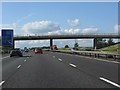
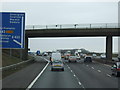
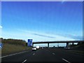
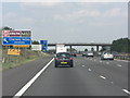
2
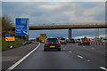
Cherwell : The M40 Northbound
The M40 between Junction 9 (Wendlebury Interchange) and Junction 10 (Ardley Interchange)
Image: © Lewis Clarke
Taken: 18 Mar 2019
0.04 miles
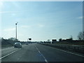
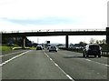
6
M40 bridge carrying minor road
The minor road joins the villages of Bucknell and Ardley.
Image: © Stuart Logan
Taken: 31 Jul 2011
0.06 miles