IMAGES TAKEN NEAR TO
Tompkins Lane, BICESTER, OX27 0EX
Introduction
This page details the photographs taken nearby to Tompkins Lane, OX27 0EX by members of the Geograph project.
The Geograph project started in 2005 with the aim of publishing, organising and preserving representative images for every square kilometre of Great Britain, Ireland and the Isle of Man.

There are currently over 7.5m images from over14,400 individuals and you can help contribute to the project by visiting https://www.geograph.org.uk
Image Map (Loading...)


Getting Data...Please wait
Leaflet Map data © OpenStreetMap
Images are licensed for reuse under creativecommons.org/licenses/by-sa/2.0
Notes
- Clicking on the map will re-center to the selected point.
- The higher the marker number, the further away the image location is from the centre of the postcode.
Image Listing (14 Images Found)
Images are licensed for reuse under creativecommons.org/licenses/by-sa/2.0
Image
Details
Distance
2
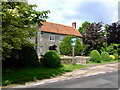
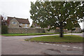
The Greyhound, Marsh Gibbon
Former home of the Phillips 1980s brewpub before moving to near Telford; Phillips not the brewery. Now with emphasis on Thai food serving beer from closer to home Greene King IPA in particular.
Image: © al partington
Taken: 29 May 2007
0.06 miles
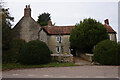
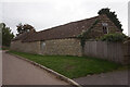
5
The Greyhound Inn (1), West Edge, Marsh Gibbon, Bucks
The only indication this is a public house appears to be the sign on the post outside. The L-shaped building is Grade II listed and seems to have been built as a public house in the 17th or 18th centuries. It was extended four bays to the east in the late 18th or early 19th century. Today it includes a restaurant with Thai cuisine. It is one of the two surviving pubs in the village. There were at one time at least two others, the Red Lion in Castle Street and the White Hart in Church Street.
Image
Image: © P L Chadwick
Taken: 20 Jul 2014
0.07 miles
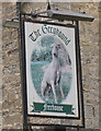
6
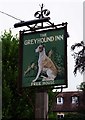
The Greyhound Inn (2) - sign, West Edge, Marsh Gibbon, Bucks
The Greyhound is a very popular name for pubs and inns, probably because when many people couldn't read or write, the greyhound was an easily recognised animal and thus the pub could be identified by the picture on its sign without difficulty. This would be especially important in places like Marsh Gibbon which used to have several pubs.
Image
Image: © P L Chadwick
Taken: 20 Jul 2014
0.07 miles
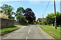
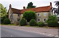
7
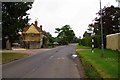
West Edge, Marsh Gibbon, Bucks
Part of the road known as West Edge, which further on becomes Church Street and then Castle Street. It is heading for Aylesbury. On the left is the junction with Tompkins Lane, which joins Bicester Road.
Image: © P L Chadwick
Taken: 20 Jul 2014
0.07 miles