IMAGES TAKEN NEAR TO
Marsh Gibbon Road, BICESTER, OX27 0AQ
Introduction
This page details the photographs taken nearby to Marsh Gibbon Road, OX27 0AQ by members of the Geograph project.
The Geograph project started in 2005 with the aim of publishing, organising and preserving representative images for every square kilometre of Great Britain, Ireland and the Isle of Man.

There are currently over 7.5m images from over14,400 individuals and you can help contribute to the project by visiting https://www.geograph.org.uk
Image Map
Images are licensed for reuse under creativecommons.org/licenses/by-sa/2.0
Notes
- Clicking on the map will re-center to the selected point.
- The higher the marker number, the further away the image location is from the centre of the postcode.
Image Listing (6 Images Found)
Images are licensed for reuse under creativecommons.org/licenses/by-sa/2.0
Image
Details
Distance
1
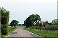
The road to Marsh Gibbon passes Essex Cottages
Image: © Steve Daniels
Taken: 23 Jun 2014
0.03 miles
2
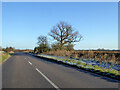
Road to Marsh Gibbon
The trees are by a wayside pond.
Image: © Robin Webster
Taken: 4 Dec 2016
0.08 miles
3
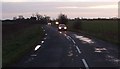
Busy lane, winter evening
The lane past Image] was very busy at about 4.00pm. There were puddles all along the road and floods in the fields bordering it further south.
(Supplementary due to lighting)
Image: © Rob Farrow
Taken: 2 Jan 2007
0.16 miles
5
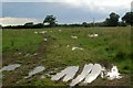
Sheep in field
A couple of wet days and the puddles return.
Image: © David Luther Thomas
Taken: 16 Jun 2007
0.24 miles
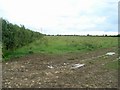
6
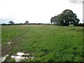
Hedge forming Northern boundary
Image: © David Luther Thomas
Taken: 16 Jun 2007
0.25 miles