IMAGES TAKEN NEAR TO
Banbury Road, OXFORD, OX2 6PE
Introduction
This page details the photographs taken nearby to Banbury Road, OX2 6PE by members of the Geograph project.
The Geograph project started in 2005 with the aim of publishing, organising and preserving representative images for every square kilometre of Great Britain, Ireland and the Isle of Man.

There are currently over 7.5m images from over14,400 individuals and you can help contribute to the project by visiting https://www.geograph.org.uk
Image Map
Images are licensed for reuse under creativecommons.org/licenses/by-sa/2.0
Notes
- Clicking on the map will re-center to the selected point.
- The higher the marker number, the further away the image location is from the centre of the postcode.
Image Listing (227 Images Found)
Images are licensed for reuse under creativecommons.org/licenses/by-sa/2.0
Image
Details
Distance
1
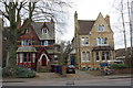
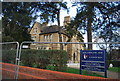
#59 and #61 Banbury Road
#59 (Hertford College Annex) is on the left and #61(School of Anthropology) on the right. There was an Ordnance Survey cut mark benchmark on the road end of the party wall, levelled at 63.49m above Newlyn datum in 1970. The wall end looks to have been rebuilt.
Image: © Roger Templeman
Taken: 30 Jan 2012
0.01 miles
2
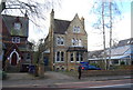
Institute of Social and Cultural Anthropology
Image: © N Chadwick
Taken: 22 Feb 2014
0.01 miles
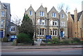
3
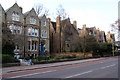
Banbury Road, Oxford
There are many of these former grand residences which have often been taken over by colleges or other academic institutions.
Image: © Bill Boaden
Taken: 6 Mar 2010
0.02 miles
4
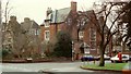
Woodlands Nursing Home on the corner of Woodstock Road and Leckford Road.
Now know as the Woodlands Eventide Home Ltd.
Image: © Roger A Smith
Taken: Unknown
0.03 miles
6
51 - 53, Banbury Rd
The school of Anthropology.
Image: © N Chadwick
Taken: 22 Feb 2014
0.03 miles
7
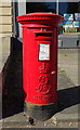
Elizabeth II postbox on Banbury Road, Oxford
Postbox No. OX2 68.
See Image] for context.
Image: © JThomas
Taken: 21 Sep 2019
0.03 miles
8
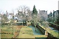
Gardens of 7-9 Winchester Road, Oxford 1980
An autumn view of the gardens of 7-9 Winchester Road, Oxford and the houses on Banbury Road onto which they abut. These houses formed a group of five, all from September 1980 used as student accommodation by Hertford College.
Image: © Peter Whatley
Taken: Unknown
0.04 miles
9
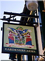
The Gardeners Arms
This is one of two pubs with this name in the locality, suggestive perhaps of all the horticultural activity once needed to keep the Oxford colleges supplied with fruit and veg.
Image: © Natasha Ceridwen de Chroustchoff
Taken: 4 Mar 2008
0.04 miles
10
Institute of Social and Cultural Anthropology
Another academic institution in a Banbury Road location. Piles of bikes outside suggest there are students attending.
Image: © Natasha Ceridwen de Chroustchoff
Taken: 4 Mar 2008
0.04 miles