IMAGES TAKEN NEAR TO
Great Clarendon Street, OXFORD, OX2 6AX
Introduction
This page details the photographs taken nearby to Great Clarendon Street, OX2 6AX by members of the Geograph project.
The Geograph project started in 2005 with the aim of publishing, organising and preserving representative images for every square kilometre of Great Britain, Ireland and the Isle of Man.

There are currently over 7.5m images from over14,400 individuals and you can help contribute to the project by visiting https://www.geograph.org.uk
Image Map
Images are licensed for reuse under creativecommons.org/licenses/by-sa/2.0
Notes
- Clicking on the map will re-center to the selected point.
- The higher the marker number, the further away the image location is from the centre of the postcode.
Image Listing (552 Images Found)
Images are licensed for reuse under creativecommons.org/licenses/by-sa/2.0
Image
Details
Distance
1
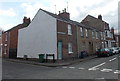
Corner of Canal Street and Great Clarendon Street, Jericho, Oxford
Great Clarendon Street is on the right.
Image: © Jaggery
Taken: 31 Mar 2013
0.02 miles
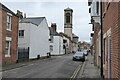
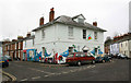
2
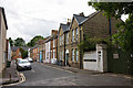
St. Barnabas Street
Located at the end of Cardigan Street, adjacent to the church of the same name. The closest house with the open door is the vicarage.
Image: © Martin Addison
Taken: 11 Aug 2010
0.02 miles
3
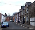
St Barnabas Street, Jericho, Oxford
Viewed from the corner of Cardigan Street along St Barnabas Street towards Great Clarendon Street.
Image: © Jaggery
Taken: 31 Mar 2013
0.02 miles
4
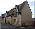
School Court, Jericho, Oxford
Houses in a converted former school, viewed across Great Clarendon Street.
Image: © Jaggery
Taken: 31 Mar 2013
0.03 miles
5
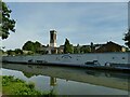
Canal Street
Canal Street in the Jericho area of Oxford. The campanile of St Barnabas church can be seen in the background.
Image: © Philip Halling
Taken: 23 Feb 2023
0.03 miles
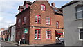
7
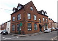
Jericho St Barnabas Community Centre, Oxford
On the corner of Cardigan Street and Canal Street, opposite St Barnabas Church.
Image: © Jaggery
Taken: 31 Mar 2013
0.04 miles
8
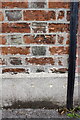
Benchmark on #35 Nelson Street
Ordnance Survey cut mark benchmark described on the Bench Mark Database at http://www.bench-marks.org.uk/bm26626
Image: © Roger Templeman
Taken: 20 Aug 2014
0.04 miles
9
Jericho Wharf development site
This was formerly the Corporation Wharf at the end of Nelson Street, still in commercial use in 1937 according to British History Online, but traffic fell by 90% by 1955 when the southern section of the canal was closed to commercial traffic. It is now being developed for housing. Source: https://www.british-history.ac.uk/vch/oxon/vol4/pp284-295 ; see also Image
Image: © Stephen Craven
Taken: 21 Sep 2021
0.04 miles
10
Corner of Wellington Street and Nelson Street
Image: © John Salmon
Taken: 27 Nov 2010
0.04 miles