IMAGES TAKEN NEAR TO
Victoria Road, BICESTER, OX26 6PR
Introduction
This page details the photographs taken nearby to Victoria Road, OX26 6PR by members of the Geograph project.
The Geograph project started in 2005 with the aim of publishing, organising and preserving representative images for every square kilometre of Great Britain, Ireland and the Isle of Man.

There are currently over 7.5m images from over14,400 individuals and you can help contribute to the project by visiting https://www.geograph.org.uk
Image Map
Images are licensed for reuse under creativecommons.org/licenses/by-sa/2.0
Notes
- Clicking on the map will re-center to the selected point.
- The higher the marker number, the further away the image location is from the centre of the postcode.
Image Listing (177 Images Found)
Images are licensed for reuse under creativecommons.org/licenses/by-sa/2.0
Image
Details
Distance
2
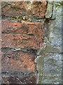
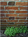
Bicester, Victoria Road
1968 Ordnance Survey cut mark benchmark on the wall junction at the rear of the Penny Black pub showing its age. The bricks carrying the cut are eroded, and although the datum cut remains clear, the arrow cuts have more or less disappeared. The mark was levelled at 72.6674m above Newlyn datum. For more information about this and other nearby marks see http://www.bench-marks.org.uk/bm33914.
Image: © Roger Templeman
Taken: 28 Apr 2010
0.07 miles
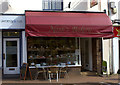
3
Former United Methodist Free Church, Bicester
Built 1863, taken over by the Wesleyans about 40 years later, and renamed Wesley Hall (still just to be made out on the elevation), and currently in use as a home furnishings shop.
Image: © Jim Osley
Taken: 5 May 2010
0.07 miles
4
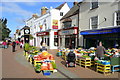
Greengrocer in Sheep Street, Bicester 1
Looking north-west along the street.
Image: © Jonathan Billinger
Taken: 1 Oct 2008
0.07 miles
5
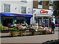
Greengrocer in Sheep Street, Bicester 2
Looking north across the pedestrianised street.
The lady is contemplating the two large pumpkins!
Image: © Jonathan Billinger
Taken: 1 Oct 2008
0.07 miles
6
Bicester, Benchmark at 1 Newport Terrace (Victoria Road)
Ordnance Survey 1968 cut mark benchmark on wall of 1 Newport Terrace. See http://www.bench-marks.org.uk/bm33915
Image: © Roger Templeman
Taken: 9 Apr 2010
0.08 miles
7
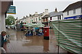
Wet end to the day's market trading
The market generally operates every Friday on Sheep Street.
Image: © Bill Boaden
Taken: 26 Jun 2015
0.08 miles
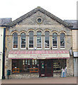
8
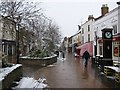
Sheep Street, Bicester
The pedestrianized main shopping street in Bicester, Sheep Street. This scene is facing North, next to the town centre clock! This street was fully pedestrianized from a normal through road back in the 1990's. The famous clock shown was manufactured and fabricated by my uncle!
Image: © Kurt C
Taken: 2 Feb 2009
0.08 miles
9

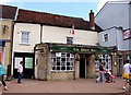
The Old Post Office (now 'Penny Black' pub)
A nice closeup shot of what for many years was the town's main Post Office, until its closure in the early 1990s. I personally can remember this superb post office in its glory days. While now a pub that is not quite to my taste (too rowdy?), original details to the exterior of its post office past still remain, as well as its suitable modern name. A superb important building that sits on Bicester's main town street, Sheep Street.
Image: © Kurt C
Taken: 25 Feb 2009
0.08 miles