IMAGES TAKEN NEAR TO
Hanover Gardens, BICESTER, OX26 6DP
Introduction
This page details the photographs taken nearby to Hanover Gardens, OX26 6DP by members of the Geograph project.
The Geograph project started in 2005 with the aim of publishing, organising and preserving representative images for every square kilometre of Great Britain, Ireland and the Isle of Man.

There are currently over 7.5m images from over14,400 individuals and you can help contribute to the project by visiting https://www.geograph.org.uk
Image Map
Images are licensed for reuse under creativecommons.org/licenses/by-sa/2.0
Notes
- Clicking on the map will re-center to the selected point.
- The higher the marker number, the further away the image location is from the centre of the postcode.
Image Listing (347 Images Found)
Images are licensed for reuse under creativecommons.org/licenses/by-sa/2.0
Image
Details
Distance
1
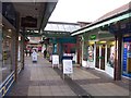
Covered Shopping Area - Bicester
A peculiar little alley of shops. I cannot recall the name. Between Sheep St and the car park. The builders did not seem to have made up their mind as to whether it was covered or open, so they made it both. Looking slightly down at heel.
Apparently called Crown Walk. Many thanks to Lindsay who E-mailed me.
Image: © Colin Babb
Taken: 30 Oct 2008
0.03 miles
2
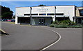
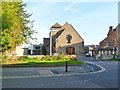
John Paul II Centre in Bicester
Located in Webb Court, on the west side of the Catholic Church of The Immaculate Conception. http://www.geograph.org.uk/photo/4562495
Officially opened by HRH The Princess Royal on November 1st 2011, the John Paul II Centre is a venue for meetings, conferences, regular and one-off events, as well as corporate and social functions.
As the largest passivhaus construction currently in the UK, the Centre has ultralow energy usage and a very small carbon footprint, through the effective use of natural light, advanced window technology and airtight insulation.
Image: © Jaggery
Taken: 9 Jul 2015
0.03 miles
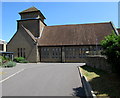
3
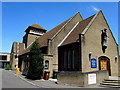
Catholic Church of The Immaculate Conception, Bicester
Set back from the north side of Causeway, the church is part of the Roman Catholic Archdiocese of Birmingham.
The church was opened and blessed by the Archbishop of Birmingham on March 23rd 1963.
Image: © Jaggery
Taken: 9 Jul 2015
0.04 miles
4
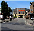
Manorsfield Road towards Sainsbury's, Bicester
Looking NNW along the B4100 Manorsfield Road from the western edge of Market Square.
The Sainsbury's supermarket in Bure Place opened in 2013.
Image: © Jaggery
Taken: 9 Jul 2015
0.04 miles
5
West side of the Catholic Church of The Immaculate Conception, Bicester
Set back from the north side of Causeway, the church is part of the Roman Catholic Archdiocese of Birmingham.
The church was opened and blessed by the Archbishop of Birmingham on March 23rd 1963.
Image: © Jaggery
Taken: 9 Jul 2015
0.05 miles
6
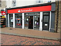
Santander Bank branch in Bicester
This bank branch is located at 15 Sheep Street OX26 6JL. To the right of the branch can be seen No 15a leading to a private clinic.
Image: © David Hillas
Taken: 2 Sep 2021
0.06 miles
7
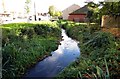
The River Bure in Bicester
The River Bure flows into the River Ray.
Image: © Steve Daniels
Taken: 28 Oct 2013
0.06 miles
8
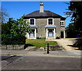
Grade II listed early Victorian houses in Bicester
Numbers 2 and 4 Church Street were built c1840. Grade II listed in 1976.
Image: © Jaggery
Taken: 9 Jul 2015
0.06 miles
9
Bicester, Roman Catholic Church
Church of the Immaculate Conception, on Causeway. http://www.immaculate-conception.org.uk/
Image: © Mike Faherty
Taken: 1 Oct 2011
0.06 miles
10
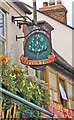
The Litten Tree pub sign, 59-61 Sheep Street
Pub sign on The Litten Tree, a popular pub and night spot in Bicester.
Image: © P L Chadwick
Taken: 12 Jun 2008
0.06 miles