IMAGES TAKEN NEAR TO
Sycamore Road, BICESTER, OX26 5DZ
Introduction
This page details the photographs taken nearby to Sycamore Road, OX26 5DZ by members of the Geograph project.
The Geograph project started in 2005 with the aim of publishing, organising and preserving representative images for every square kilometre of Great Britain, Ireland and the Isle of Man.

There are currently over 7.5m images from over14,400 individuals and you can help contribute to the project by visiting https://www.geograph.org.uk
Image Map
Images are licensed for reuse under creativecommons.org/licenses/by-sa/2.0
Notes
- Clicking on the map will re-center to the selected point.
- The higher the marker number, the further away the image location is from the centre of the postcode.
Image Listing (36 Images Found)
Images are licensed for reuse under creativecommons.org/licenses/by-sa/2.0
Image
Details
Distance
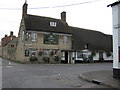
1
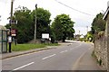
Bicester Road, Launton
Launton still has a village feel to it, but with the rate that Bicester is spreading I wonder how much longer that will last.
Image: © Des Blenkinsopp
Taken: 14 Sep 2019
0.12 miles
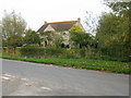

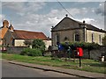
8
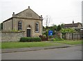
Launton: Bethel Congregational Church
The carved stone tablet in the gable gives a date of 1850 for this chapel. The village pump, seen in close-up here Image is inside the railing enclosure on the right.
Image: © Nigel Cox
Taken: 18 Jun 2013
0.14 miles
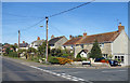
9
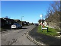
Bethel Congregational Church and Launton pump
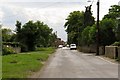
On Station Road, an arm of the Launton crossroads that clearly predates the Cambridge to Oxford railway.
Image: © Chris Brown
Taken: 25 Aug 2018
0.14 miles