IMAGES TAKEN NEAR TO
Chesterton, BICESTER, OX26 1XA
Introduction
This page details the photographs taken nearby to OX26 1XA by members of the Geograph project.
The Geograph project started in 2005 with the aim of publishing, organising and preserving representative images for every square kilometre of Great Britain, Ireland and the Isle of Man.

There are currently over 7.5m images from over14,400 individuals and you can help contribute to the project by visiting https://www.geograph.org.uk
Image Map
Images are licensed for reuse under creativecommons.org/licenses/by-sa/2.0
Notes
- Clicking on the map will re-center to the selected point.
- The higher the marker number, the further away the image location is from the centre of the postcode.
Image Listing (10 Images Found)
Images are licensed for reuse under creativecommons.org/licenses/by-sa/2.0
Image
Details
Distance
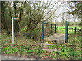
2
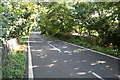
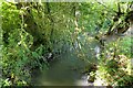
Bridge over Gagle Brook east of Chesterton
There is an OS benchmark Image on the road face of the right hand parapet at its near end
Image: © Roger Templeman
Taken: 23 Sep 2016
0.21 miles
3
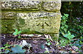
Benchmark on Gagle Brook bridge
Ordnance Survey cut mark benchmark described on the Bench Mark Database at http://www.bench-marks.org.uk/bm79260
Image: © Roger Templeman
Taken: 23 Sep 2016
0.21 miles
4
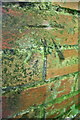
Benchmark on brick cowshed at Lodge Farm
Ordnance Survey cut mark benchmark described on the Bench Mark Database at http://www.bench-marks.org.uk/bm79259
Image: © Roger Templeman
Taken: 23 Sep 2016
0.23 miles
5
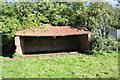
Brick cowshed beside telecoms mast at Lodge Farm
There is an OS benchmark Image on the right hand side of the shed
Image: © Roger Templeman
Taken: 23 Sep 2016
0.23 miles
6
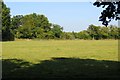
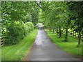
Field by Wendlebury Road
A footpath runs across the field to the caravan park.
Image: © Steve Daniels
Taken: 29 Sep 2013
0.23 miles
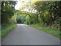
10
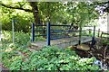
Footbridge over Gagle Brook
The footpath runs to the caravan park.
Image: © Steve Daniels
Taken: 29 Sep 2013
0.24 miles