IMAGES TAKEN NEAR TO
Kirtlington Road, OX26 1TG
Introduction
This page details the photographs taken nearby to Kirtlington Road, OX26 1TG by members of the Geograph project.
The Geograph project started in 2005 with the aim of publishing, organising and preserving representative images for every square kilometre of Great Britain, Ireland and the Isle of Man.

There are currently over 7.5m images from over14,400 individuals and you can help contribute to the project by visiting https://www.geograph.org.uk
Image Map
Images are licensed for reuse under creativecommons.org/licenses/by-sa/2.0
Notes
- Clicking on the map will re-center to the selected point.
- The higher the marker number, the further away the image location is from the centre of the postcode.
Image Listing (5 Images Found)
Images are licensed for reuse under creativecommons.org/licenses/by-sa/2.0
Image
Details
Distance
1
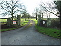
The Road to Simms Farm
This road is the northern entrance to Simms Farm, and the two signs say no lorries.
Image: © Alexander P Kapp
Taken: 21 Feb 2007
0.12 miles
2
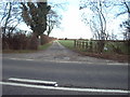
The Road to Simms Farm
This is the road that lorries can use to access the farm
Image: © Alexander P Kapp
Taken: 21 Feb 2007
0.17 miles
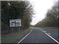
5
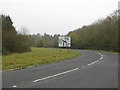
Bend in the A4095 as it approaches the junction with the B430
Image: © Sarah Charlesworth
Taken: 9 Nov 2009
0.23 miles