IMAGES TAKEN NEAR TO
Eridge Road, OX26 1EZ
Introduction
This page details the photographs taken nearby to Eridge Road, OX26 1EZ by members of the Geograph project.
The Geograph project started in 2005 with the aim of publishing, organising and preserving representative images for every square kilometre of Great Britain, Ireland and the Isle of Man.

There are currently over 7.5m images from over14,400 individuals and you can help contribute to the project by visiting https://www.geograph.org.uk
Image Map
Images are licensed for reuse under creativecommons.org/licenses/by-sa/2.0
Notes
- Clicking on the map will re-center to the selected point.
- The higher the marker number, the further away the image location is from the centre of the postcode.
Image Listing (9 Images Found)
Images are licensed for reuse under creativecommons.org/licenses/by-sa/2.0
Image
Details
Distance
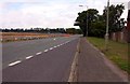
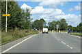
3
Road junction on the edge of Bicester
Image: © Sarah Charlesworth
Taken: 13 Nov 2009
0.16 miles
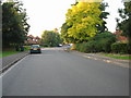
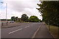
4
Shakespeare Drive in Bicester with Wear Road on the right
Image: © Steve Daniels
Taken: 14 Aug 2010
0.17 miles
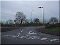
5
Roundabout on A4095, Bicester
The junction for the B4030 to the west, and a road into town.
Image: © Robin Webster
Taken: 22 Aug 2020
0.18 miles
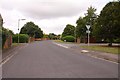
6
The junction of Shakespeare Drive and Middleton Cheney Road
Image: © Steve Daniels
Taken: 14 Aug 2010
0.19 miles
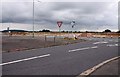
8
New development on Middleton Cheney Road
Image: © Steve Daniels
Taken: 14 Aug 2010
0.21 miles
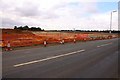
9
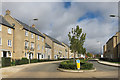
Whitelands Way, Bicester
Presumably on ex fields of nearby Whitelands Farm, this is a very recent addition to ever expanding Bicester.
Somebody said this is the fastest growing town in Europe.
I remember when that distinction went to Swindon.
Aah, nostalgia....
Image: © Des Blenkinsopp
Taken: 12 Sep 2015
0.22 miles