IMAGES TAKEN NEAR TO
Flavian Close, BICESTER, OX26 1DF
Introduction
This page details the photographs taken nearby to Flavian Close, OX26 1DF by members of the Geograph project.
The Geograph project started in 2005 with the aim of publishing, organising and preserving representative images for every square kilometre of Great Britain, Ireland and the Isle of Man.

There are currently over 7.5m images from over14,400 individuals and you can help contribute to the project by visiting https://www.geograph.org.uk
Image Map
Images are licensed for reuse under creativecommons.org/licenses/by-sa/2.0
Notes
- Clicking on the map will re-center to the selected point.
- The higher the marker number, the further away the image location is from the centre of the postcode.
Image Listing (14 Images Found)
Images are licensed for reuse under creativecommons.org/licenses/by-sa/2.0
Image
Details
Distance
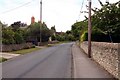
1
Traffic calming on the outskirts of Chesterton
Image: © Sarah Charlesworth
Taken: 1 Jun 2010
0.08 miles
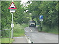
2
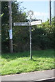
Chesterton: Akeman Street
Akeman Street linked Watling Street near St Albans with the Fosse Way at Cirencester. At this crossroads there is a fine old Oxfordshire County Council fingerpost. Chesterton is ahead and Kirtlington behind the photographer.
Image: © Nigel Cox
Taken: 18 May 2013
0.14 miles
3
Flags by the Wall, Chesterton
Red, white and blue flags along a school wall on the way into Chesterton. Taken in Summer 2020 in the midst of the coronavirus epidemic when many people put out flags, banners and posters in support of the National Health Service.
Image: © Des Blenkinsopp
Taken: 15 Jun 2020
0.18 miles
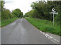
4
Signpost at Green Lane / Alchester Road junction
Image: © Roger Templeman
Taken: 23 Sep 2016
0.18 miles
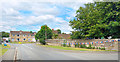
5
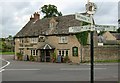
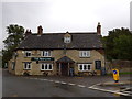
The Red Cow pub, Chesterton
One of my best pictures in this area, and of a superb example of a traditional village pub. The Red Cow has stood proudly for many many years on the junction of the minor link road to the A41, and the minor through road that leads to Weston On The Green some 2 miles away. A lovely example of an old signpost is located here, though such signposts are sadly an increasing rarity.
Image: © Kurt C
Taken: 28 Jul 2007
0.18 miles
6
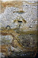
Benchmark on The Red Cow
Ordnance Survey cut mark benchmark described on the Bench Mark Database at http://www.bench-marks.org.uk/bm79287
Image: © Roger Templeman
Taken: 23 Sep 2016
0.18 miles
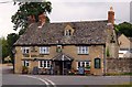
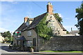
8
The Red Cow, Chesterton: September 2015
Image: © Basher Eyre
Taken: 21 Sep 2015
0.19 miles
9
The Red Cow
There is an OS benchmark Image on the near corner of the pub, left of the downpipe
Image: © Roger Templeman
Taken: 23 Sep 2016
0.19 miles