IMAGES TAKEN NEAR TO
Cartmel, BICESTER, OX26 1AH
Introduction
This page details the photographs taken nearby to Cartmel, OX26 1AH by members of the Geograph project.
The Geograph project started in 2005 with the aim of publishing, organising and preserving representative images for every square kilometre of Great Britain, Ireland and the Isle of Man.

There are currently over 7.5m images from over14,400 individuals and you can help contribute to the project by visiting https://www.geograph.org.uk
Image Map
Images are licensed for reuse under creativecommons.org/licenses/by-sa/2.0
Notes
- Clicking on the map will re-center to the selected point.
- The higher the marker number, the further away the image location is from the centre of the postcode.
Image Listing (6 Images Found)
Images are licensed for reuse under creativecommons.org/licenses/by-sa/2.0
Image
Details
Distance
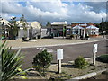
1
View north-west out of the Premier Inn, Oxford Road, Bicester
Considerable house-building is taking place on this western fringe of Bicester and the fields here will probably soon be covered.
Image: © Christopher Hilton
Taken: 15 May 2015
0.16 miles
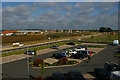
2
Premier Inn, Oxford Road, Bicester
Image: © Christopher Hilton
Taken: 14 May 2015
0.20 miles
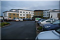
4
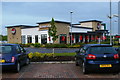
Brewers Fayre restaurant, Oxford Road, Bicester
Part of the same complex as the adjacent Premier Inn.
Image: © Christopher Hilton
Taken: 14 May 2015
0.22 miles
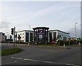
5
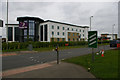
Premier Inn, Oxford Road, Bicester
Image: © Christopher Hilton
Taken: 15 May 2015
0.22 miles