IMAGES TAKEN NEAR TO
Somerton, BICESTER, OX25 6LX
Introduction
This page details the photographs taken nearby to OX25 6LX by members of the Geograph project.
The Geograph project started in 2005 with the aim of publishing, organising and preserving representative images for every square kilometre of Great Britain, Ireland and the Isle of Man.

There are currently over 7.5m images from over14,400 individuals and you can help contribute to the project by visiting https://www.geograph.org.uk
Image Map
Images are licensed for reuse under creativecommons.org/licenses/by-sa/2.0
Notes
- Clicking on the map will re-center to the selected point.
- The higher the marker number, the further away the image location is from the centre of the postcode.
Image Listing (4 Images Found)
Images are licensed for reuse under creativecommons.org/licenses/by-sa/2.0
Image
Details
Distance
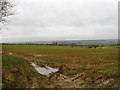
1
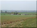
Mudginwell Farm
Nestling in a fold of land above the Cherwell Valley.
Image: © Jonathan Billinger
Taken: 12 Apr 2007
0.03 miles
4
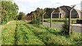
Bridleway to Village Farm
Bridleway to Village Farm running alongside the fence of the former USAF Upper Heyford airfield with one of it hardened aircraft shelters
Image: © Shaun Ferguson
Taken: 7 Oct 2020
0.21 miles