IMAGES TAKEN NEAR TO
Somerton, BICESTER, OX25 6LU
Introduction
This page details the photographs taken nearby to OX25 6LU by members of the Geograph project.
The Geograph project started in 2005 with the aim of publishing, organising and preserving representative images for every square kilometre of Great Britain, Ireland and the Isle of Man.

There are currently over 7.5m images from over14,400 individuals and you can help contribute to the project by visiting https://www.geograph.org.uk
Image Map
Images are licensed for reuse under creativecommons.org/licenses/by-sa/2.0
Notes
- Clicking on the map will re-center to the selected point.
- The higher the marker number, the further away the image location is from the centre of the postcode.
Image Listing (8 Images Found)
Images are licensed for reuse under creativecommons.org/licenses/by-sa/2.0
Image
Details
Distance
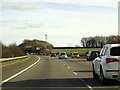
2
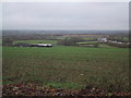
Fields by Souldern Grounds Farm
The M40 can be seen in the distance.
Image: © Sarah Charlesworth
Taken: 13 Nov 2009
0.16 miles
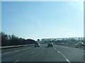

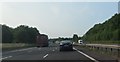
5
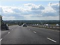
M40 panorama north of Fritwell
The motorway is about to descend steeply into the Cherwell Valley.
Image: © Peter Whatley
Taken: 19 Jun 2012
0.19 miles
6
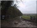
Muddy entrance to Souldern Grounds Farm
Image: © Sarah Charlesworth
Taken: 13 Nov 2009
0.20 miles