IMAGES TAKEN NEAR TO
Duns Tew, BICESTER, OX25 6JS
Introduction
This page details the photographs taken nearby to OX25 6JS by members of the Geograph project.
The Geograph project started in 2005 with the aim of publishing, organising and preserving representative images for every square kilometre of Great Britain, Ireland and the Isle of Man.

There are currently over 7.5m images from over14,400 individuals and you can help contribute to the project by visiting https://www.geograph.org.uk
Image Map
Images are licensed for reuse under creativecommons.org/licenses/by-sa/2.0
Notes
- Clicking on the map will re-center to the selected point.
- The higher the marker number, the further away the image location is from the centre of the postcode.
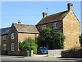
Image Listing (35 Images Found)
Images are licensed for reuse under creativecommons.org/licenses/by-sa/2.0
Image
Details
Distance
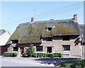
3
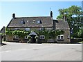
Duns Tew-The White Horse Inn
Public House on Main Street.
Image: © Ian Rob
Taken: 27 Jun 2019
0.04 miles
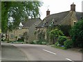
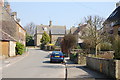
9
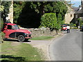
Village street scene
A view along the main road through Duns Tew.
Image: © Michael Trolove
Taken: 22 May 2010
0.08 miles
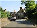
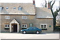
10

White Horse Inn, Duns Tew on 6th April 2008
Image: © Jos Joslin
Taken: 6 Apr 2008
0.09 miles