IMAGES TAKEN NEAR TO
Middle Aston, BICESTER, OX25 5QF
Introduction
This page details the photographs taken nearby to OX25 5QF by members of the Geograph project.
The Geograph project started in 2005 with the aim of publishing, organising and preserving representative images for every square kilometre of Great Britain, Ireland and the Isle of Man.

There are currently over 7.5m images from over14,400 individuals and you can help contribute to the project by visiting https://www.geograph.org.uk
Image Map
Images are licensed for reuse under creativecommons.org/licenses/by-sa/2.0
Notes
- Clicking on the map will re-center to the selected point.
- The higher the marker number, the further away the image location is from the centre of the postcode.
Image Listing (9 Images Found)
Images are licensed for reuse under creativecommons.org/licenses/by-sa/2.0
Image
Details
Distance
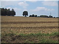
1
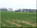
Warren Farm
A view across the wheat fields.
Image: © Jonathan Billinger
Taken: 12 Apr 2007
0.05 miles
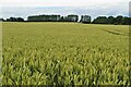
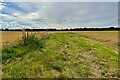
5
Unfenced field near Warren Lodge
Image: © Sarah Charlesworth
Taken: 19 Aug 2011
0.20 miles
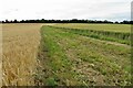
7
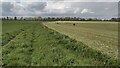
Bridleway to Oxford Road
From Middle Aston the bridleway to Oxford Road
Image: © Shaun Ferguson
Taken: 30 Apr 2021
0.23 miles
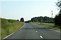
8
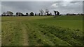
Bridleway heading to Middle Aston
From Oxford Road the bridleway heading to Middle Aston
Image: © Shaun Ferguson
Taken: 30 Apr 2021
0.23 miles
9
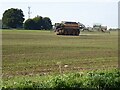
Vredo 7028-3 Self-Propelled Slurry Tanker
A Vredo 7028-3 Self-Propelled Slurry Tanker spreading slurry on arable land near Middle Aston. This huge vehicle which is operated by RC Baker agricultural contractors is new to the UK and has the appearance of a machine from Thunderbirds.
Image: © Philip Halling
Taken: 6 Sep 2021
0.24 miles