IMAGES TAKEN NEAR TO
North Aston Road, BICESTER, OX25 5QD
Introduction
This page details the photographs taken nearby to North Aston Road, OX25 5QD by members of the Geograph project.
The Geograph project started in 2005 with the aim of publishing, organising and preserving representative images for every square kilometre of Great Britain, Ireland and the Isle of Man.

There are currently over 7.5m images from over14,400 individuals and you can help contribute to the project by visiting https://www.geograph.org.uk
Image Map
Images are licensed for reuse under creativecommons.org/licenses/by-sa/2.0
Notes
- Clicking on the map will re-center to the selected point.
- The higher the marker number, the further away the image location is from the centre of the postcode.
Image Listing (8 Images Found)
Images are licensed for reuse under creativecommons.org/licenses/by-sa/2.0
Image
Details
Distance
1
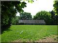
Hendon Farm
A building on the Hendon Farm estate.
Image: © Mr Biz
Taken: 13 May 2008
0.03 miles
2
Hendon Cottages along Middle Aston Road
Image: © Mat Fascione
Taken: 7 Jun 2015
0.12 miles
3
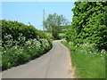
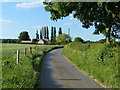
Middle Aston Lane
Middle Aston Lane looking north towards North Aston.
Image: © Mr Biz
Taken: 13 May 2008
0.17 miles
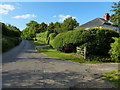
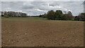
4
Entrance to Grange Farm
The entrance to Grange Farm and bridleway, just off of Middle Aston Lane.
Image: © Mr Biz
Taken: 13 May 2008
0.18 miles
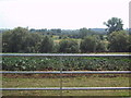
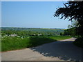
5
Bridleway crosses the road near Warren Lodge
Image: © Sarah Charlesworth
Taken: 19 Aug 2011
0.20 miles
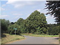
6
Path heading to Middle Aston Lane
Path heading past the copse to Middle Aston Lane
Image: © Shaun Ferguson
Taken: 30 Apr 2021
0.24 miles