IMAGES TAKEN NEAR TO
Church Lane, BICESTER, OX25 5NZ
Introduction
This page details the photographs taken nearby to Church Lane, OX25 5NZ by members of the Geograph project.
The Geograph project started in 2005 with the aim of publishing, organising and preserving representative images for every square kilometre of Great Britain, Ireland and the Isle of Man.

There are currently over 7.5m images from over14,400 individuals and you can help contribute to the project by visiting https://www.geograph.org.uk
Image Map
Images are licensed for reuse under creativecommons.org/licenses/by-sa/2.0
Notes
- Clicking on the map will re-center to the selected point.
- The higher the marker number, the further away the image location is from the centre of the postcode.
Image Listing (91 Images Found)
Images are licensed for reuse under creativecommons.org/licenses/by-sa/2.0
Image
Details
Distance
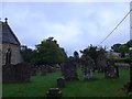
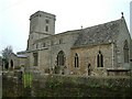
1
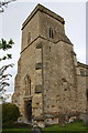
Tower of St Mary's Church
There is an OS benchmark Image in the stonework on the near side of the tower door
Image: © Roger Templeman
Taken: 27 Apr 2016
0.03 miles
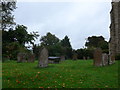
5
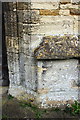
Benchmark on St Mary's Church
Ordnance Survey cut mark benchmark described on the Bench Mark Database at http://www.bench-marks.org.uk/bm32279
Image: © Roger Templeman
Taken: 27 Apr 2016
0.03 miles
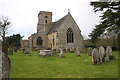
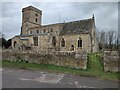
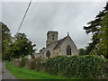
6
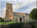
St Mary's Church, Lower Heyford
Grade II* listed. Listing number 1225457. Church. C13, C14 and C15, restored 1848 by H.J. Underwood, and 1867 by C. Buckeridge.
Image: © Andrew Abbott
Taken: 8 Sep 2020
0.03 miles
10

Oxford Canal and towpath at Lower Heyford
Image: © Mat Fascione
Taken: 7 Jun 2015
0.08 miles