IMAGES TAKEN NEAR TO
Bromeswell Close, BICESTER, OX25 5NU
Introduction
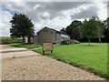
This page details the photographs taken nearby to Bromeswell Close, OX25 5NU by members of the Geograph project.
The Geograph project started in 2005 with the aim of publishing, organising and preserving representative images for every square kilometre of Great Britain, Ireland and the Isle of Man.

There are currently over 7.5m images from over14,400 individuals and you can help contribute to the project by visiting https://www.geograph.org.uk
Image Map
Images are licensed for reuse under creativecommons.org/licenses/by-sa/2.0
Notes
- Clicking on the map will re-center to the selected point.
- The higher the marker number, the further away the image location is from the centre of the postcode.
Image Listing (38 Images Found)
Images are licensed for reuse under creativecommons.org/licenses/by-sa/2.0
Image
Details
Distance
1
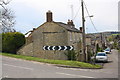
Junction of Freehold Street and B4030
There is an OS benchmark Image on the left hand corner on the nearest house (at its junction with an outbuilding with a sloping roof)
Image: © Roger Templeman
Taken: 27 Apr 2016
0.05 miles
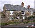
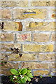
2
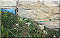
Benchmark on #134 Freehold Street
Ordnance Survey cut mark benchmark described on the Bench Mark Database at http://www.bench-marks.org.uk/bm76015
Image: © Roger Templeman
Taken: 27 Apr 2016
0.05 miles
3
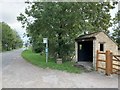
Lower Heyford bus shelter
On Station Road.
Image: © Andrew Abbott
Taken: 8 Sep 2020
0.06 miles
4
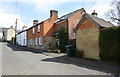
Outbuilding and houses on the south side of Freehold Street
There is an OS benchmark Image at the middle of the road face of the outbuilding above a primrose.
Image: © Roger Templeman
Taken: 27 Apr 2016
0.07 miles
7
Old Toll House, Station Road, Lower Heyford
Toll House in the parish of Lower Heyford, Tollgate Cottage, Station Road (B4030), OX25 5PE.
Oxfordshire HER.
HER Number: 5958 https://www.heritagegateway.org.uk/Gateway/Results_Single.aspx?uid=MOX3529&resourceID=1033
Surveyed
Milestone Society National ID: OX.LOW
Image: © Alan Rosevear
Taken: 16 Jan 2005
0.08 miles
8

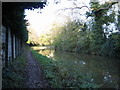
Lower Heyford Cherwell Valley in Evening Mist
Image: © Chris Cox
Taken: 12 Dec 2006
0.09 miles
9
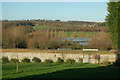
River Cherwell Floods at Lower Heyford
Views over to Steeple Aston
Image: © Chris Cox
Taken: 12 Dec 2006
0.09 miles
10
Benchmark on outbuilding west of #92 Freehold Street
Ordnance Survey cut mark benchmark described on the Bench Mark Database at http://www.bench-marks.org.uk/bm76016
Image: © Roger Templeman
Taken: 27 Apr 2016
0.10 miles