IMAGES TAKEN NEAR TO
School Lane, BICESTER, OX25 5LT
Introduction
This page details the photographs taken nearby to School Lane, OX25 5LT by members of the Geograph project.
The Geograph project started in 2005 with the aim of publishing, organising and preserving representative images for every square kilometre of Great Britain, Ireland and the Isle of Man.

There are currently over 7.5m images from over14,400 individuals and you can help contribute to the project by visiting https://www.geograph.org.uk
Image Map
Images are licensed for reuse under creativecommons.org/licenses/by-sa/2.0
Notes
- Clicking on the map will re-center to the selected point.
- The higher the marker number, the further away the image location is from the centre of the postcode.
Image Listing (59 Images Found)
Images are licensed for reuse under creativecommons.org/licenses/by-sa/2.0
Image
Details
Distance
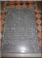
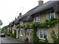
1

Thatched cottages in High Street Upper Heyford
Image: © michael
Taken: 26 Apr 2007
0.02 miles
3
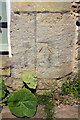
Benchmark on The Old School
Ordnance Survey cut mark benchmark described on the Bench Mark Database at http://www.bench-marks.org.uk/bm75699
Image: © Roger Templeman
Taken: 27 Apr 2016
0.04 miles
4
The Old School, School Lane
There is an OS benchmark Image to the right of the porch door
Image: © Roger Templeman
Taken: 27 Apr 2016
0.04 miles
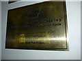
5

Upper Heyford-The Reading Room
Dating from 1892.
Image: © Ian Rob
Taken: 15 Aug 2019
0.04 miles
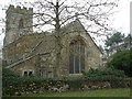
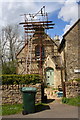
7

Benchmark on buttress of St Mary's Church
Ordnance Survey cut mark benchmark described on the Bench Mark Database at http://www.bench-marks.org.uk/bm75700
Image: © Roger Templeman
Taken: 27 Apr 2016
0.12 miles
8
St Mary, Upper Heyford: diamond jubilee (2012)
Image: © Basher Eyre
Taken: 21 Sep 2015
0.12 miles
9
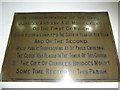
St Mary, Upper Heyford: diamond jubilee (1897)
Image: © Basher Eyre
Taken: 21 Sep 2015
0.12 miles