IMAGES TAKEN NEAR TO
Camp Road, BICESTER, OX25 5LS
Introduction
This page details the photographs taken nearby to Camp Road, OX25 5LS by members of the Geograph project.
The Geograph project started in 2005 with the aim of publishing, organising and preserving representative images for every square kilometre of Great Britain, Ireland and the Isle of Man.

There are currently over 7.5m images from over14,400 individuals and you can help contribute to the project by visiting https://www.geograph.org.uk
Image Map
Images are licensed for reuse under creativecommons.org/licenses/by-sa/2.0
Notes
- Clicking on the map will re-center to the selected point.
- The higher the marker number, the further away the image location is from the centre of the postcode.
Image Listing (6 Images Found)
Images are licensed for reuse under creativecommons.org/licenses/by-sa/2.0
Image
Details
Distance

2
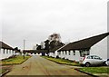
Trenchard Circus, Upper Heyford Airfield
Image: © Alex McGregor
Taken: 19 Feb 2015
0.13 miles
3
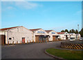
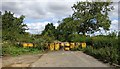
Upper Heyford Commissary
A fairly typical scene on the old Upper Heyford airbase. Some units are now rented out for business use while others have remained pretty much untouched since the US military left here back in 1993.
Image: © Des Blenkinsopp
Taken: 12 Mar 2012
0.16 miles
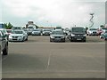
4
Car Storage
From the redeveloped Hampden Square looking through the wire to the car storage on the old USAF Upper Heyford
Image: © Shaun Ferguson
Taken: 11 Aug 2020
0.17 miles
5
Upper Heyford Airfield (disused)
Looking towards the former air traffic control tower.
Image: © David Luther Thomas
Taken: 11 Jun 2007
0.19 miles
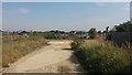
6
Upper Heyford-Chilgrove Drive
Old closed road with no access to the airfield.
Image: © Ian Rob
Taken: 15 Aug 2019
0.25 miles