IMAGES TAKEN NEAR TO
Somerton Road, BICESTER, OX25 5LB
Introduction
This page details the photographs taken nearby to Somerton Road, OX25 5LB by members of the Geograph project.
The Geograph project started in 2005 with the aim of publishing, organising and preserving representative images for every square kilometre of Great Britain, Ireland and the Isle of Man.

There are currently over 7.5m images from over14,400 individuals and you can help contribute to the project by visiting https://www.geograph.org.uk
Image Map
Images are licensed for reuse under creativecommons.org/licenses/by-sa/2.0
Notes
- Clicking on the map will re-center to the selected point.
- The higher the marker number, the further away the image location is from the centre of the postcode.
Image Listing (20 Images Found)
Images are licensed for reuse under creativecommons.org/licenses/by-sa/2.0
Image
Details
Distance
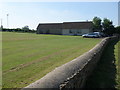
2
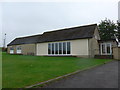
Upper Heyford Village Hall: September 2015
Image: © Basher Eyre
Taken: 21 Sep 2015
0.04 miles
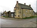
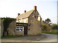
3
Upper Heyford-The Barley Mow
Public House at the junction of Mill Lane and Somerton Road.
Image: © Ian Rob
Taken: 27 Jun 2019
0.04 miles
5
The Barley Mow Pub, Upper Heyford
Summerton Road, Upper Heyford, Bicester, OX25 5LB close to the Oxford Canal
Image: © canalandriversidepubs co uk
Taken: 5 Feb 2010
0.06 miles
6
The Barley Mow, Upper Heyford: September 2015
Image: © Basher Eyre
Taken: 21 Sep 2015
0.09 miles
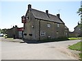
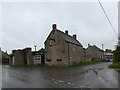
7
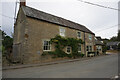
'Rose Cottage' at High Street / Somerton Road junction
Image: © Roger Templeman
Taken: 27 Apr 2016
0.09 miles
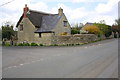
10
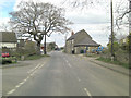
Somerton Road at junction with Orchard Lane
Image: © Stuart Logan
Taken: 31 Mar 2013
0.13 miles