IMAGES TAKEN NEAR TO
McGuire Road, BICESTER, OX25 5DU
Introduction
This page details the photographs taken nearby to McGuire Road, OX25 5DU by members of the Geograph project.
The Geograph project started in 2005 with the aim of publishing, organising and preserving representative images for every square kilometre of Great Britain, Ireland and the Isle of Man.

There are currently over 7.5m images from over14,400 individuals and you can help contribute to the project by visiting https://www.geograph.org.uk
Image Map
Images are licensed for reuse under creativecommons.org/licenses/by-sa/2.0
Notes
- Clicking on the map will re-center to the selected point.
- The higher the marker number, the further away the image location is from the centre of the postcode.
Image Listing (16 Images Found)
Images are licensed for reuse under creativecommons.org/licenses/by-sa/2.0
Image
Details
Distance
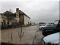
1
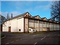
Building 151
Former airfield building now part of a business park.
Image: © Des Blenkinsopp
Taken: 12 Mar 2012
0.04 miles
2
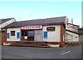
Skyking Theater
Another boarded up and disused facility on the Upper Heyford site.
Image: © Des Blenkinsopp
Taken: 12 Mar 2012
0.05 miles
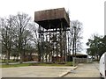
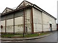
3
Communications Building
The sign reads 620th Communications Squadron. This was a working military airfield until 1993 but a lot of the buildings look distinctly World War 2.
Nice to know our taxes aren't being frittered on fancy huts.
Image: © Des Blenkinsopp
Taken: 12 Mar 2012
0.05 miles
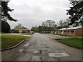
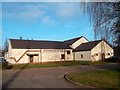
5
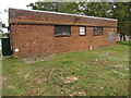
Upper Heyford Telephone Exchange (2)
This photo shows the back of the redbrick building in Heyford Park. This area is currently undergoing a redevelopment programme having previously been a Royal Air Force base until 1994. The numbering range of this TE is (01869) 23xxxx, the (01869) referring to the Bicester group of ten TEs, and its postcode is OX25 5HA.
Image: © David Hillas
Taken: 2 Sep 2021
0.08 miles
6
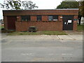
Upper Heyford Telephone Exchange (1)
Located at 148 Heyford Park off Camp Road, this redbrick building rather resembles an army store. It has the code SMUH and provides telephone and broadband services to Heyford Park plus Upper Heyford nearby. A white BT warning notice can be seen on the right hand door.
Image: © David Hillas
Taken: 2 Sep 2021
0.08 miles